IMAGES TAKEN NEAR TO
Meigle, BLAIRGOWRIE, PH12 8QX
Introduction
This page details the photographs taken nearby to PH12 8QX by members of the Geograph project.
The Geograph project started in 2005 with the aim of publishing, organising and preserving representative images for every square kilometre of Great Britain, Ireland and the Isle of Man.

There are currently over 7.5m images from over14,400 individuals and you can help contribute to the project by visiting https://www.geograph.org.uk
Image Map
Images are licensed for reuse under creativecommons.org/licenses/by-sa/2.0
Notes
- Clicking on the map will re-center to the selected point.
- The higher the marker number, the further away the image location is from the centre of the postcode.
Image Listing (5 Images Found)
Images are licensed for reuse under creativecommons.org/licenses/by-sa/2.0
Image
Details
Distance

2
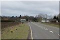
A94, Longleys
Laybys conveniently placed for the camera vans. The telephone box Image has now been removed.
Image: © Richard Webb
Taken: 29 Mar 2015
0.03 miles
3
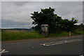
Roadside phonebox, Longleys
Like most phone boxes these days, it looks rather unloved.
Image: © Mike Pennington
Taken: 30 Jul 2010
0.04 miles
4
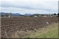
Field, Longleys
Cultivated, ready for spring cereals.
Image: © Richard Webb
Taken: 29 Mar 2015
0.11 miles
5

Old Milepost off the A94, Mains of Arthurstone, Coupar Angus parish
Milepost by the A94, in parish of Coupar Angus (District), Mains of Arthurstone, in private back garden, close to its original position.
Inscription reads:-
: 14 / TO / FORFAR : : MEIGLE 1¾ / Co.ANGUS 3¼ : : 16 / TO / PERTH :
Surveyed
Milestone Society National ID: PK_PTFR16
Image: © Milestone Society
Taken: Unknown
0.19 miles