IMAGES TAKEN NEAR TO
Meigle, BLAIRGOWRIE, PH12 8QT
Introduction
This page details the photographs taken nearby to PH12 8QT by members of the Geograph project.
The Geograph project started in 2005 with the aim of publishing, organising and preserving representative images for every square kilometre of Great Britain, Ireland and the Isle of Man.

There are currently over 7.5m images from over14,400 individuals and you can help contribute to the project by visiting https://www.geograph.org.uk
Image Map
Images are licensed for reuse under creativecommons.org/licenses/by-sa/2.0
Notes
- Clicking on the map will re-center to the selected point.
- The higher the marker number, the further away the image location is from the centre of the postcode.
Image Listing (5 Images Found)
Images are licensed for reuse under creativecommons.org/licenses/by-sa/2.0
Image
Details
Distance
3
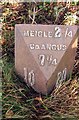
Old Milepost by the A94, Arnbog, Meigle parish
Milepost by the A94, in parish of Meigle ( District), Arnbog, on grass verge.
Inscription reads:-
: 10 : : MEIGLE 2¼ / Co.ANGUS / 7¼ : : 20 :
(To Forfar, Coupar Angus and Perth)
Surveyed
Milestone Society National ID: PK_PTFR20
Image: © Milestone Society
Taken: Unknown
0.07 miles
4
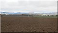
Field, Arnbog
Being prepared for spring cereals.
Image: © Richard Webb
Taken: 29 Mar 2015
0.12 miles
5
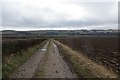
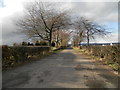
Farm track, Arnbog
The road appears quite well used, and there were numerous foot and tyre tracks in soft mud.
Image: © Richard Webb
Taken: 29 Mar 2015
0.20 miles