IMAGES TAKEN NEAR TO
Drumkilbo Road, BLAIRGOWRIE, PH12 8AD
Introduction
This page details the photographs taken nearby to Drumkilbo Road, PH12 8AD by members of the Geograph project.
The Geograph project started in 2005 with the aim of publishing, organising and preserving representative images for every square kilometre of Great Britain, Ireland and the Isle of Man.

There are currently over 7.5m images from over14,400 individuals and you can help contribute to the project by visiting https://www.geograph.org.uk
Image Map
Images are licensed for reuse under creativecommons.org/licenses/by-sa/2.0
Notes
- Clicking on the map will re-center to the selected point.
- The higher the marker number, the further away the image location is from the centre of the postcode.
Image Listing (46 Images Found)
Images are licensed for reuse under creativecommons.org/licenses/by-sa/2.0
Image
Details
Distance
1

Outside the shop, Meigle
Waiting patiently.
Image: © Richard Webb
Taken: 29 Mar 2015
0.08 miles
2
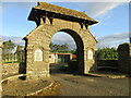
Meigle War Memorial
The war memorial at Meigle, taking the form of an arched entrance to Victory Park, on Ardler Road.
Image: © Scott Cormie
Taken: 24 May 2020
0.09 miles
3
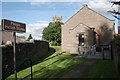
Meigle Museum
A former school room built in 1844, this Category C listed building [http://portal.historicenvironment.scot/designation/LB18327] is now the Meigle Museum and houses a fine collection of Pictish carved stones from the local area. It is run by Historic Environment Scotland.
Meigle Church can be seen behind.
Image: © Richard Sutcliffe
Taken: 28 Sep 2017
0.09 miles
4

Meigle Museum
One of the fine collection of Pictish sculptured stones housed in the little museum at Meigle.
Image: © Anne Burgess
Taken: Unknown
0.09 miles
5
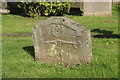
18th century gravestone, Meigle Churchyard
With the initials 'ML' and dated 1742, this gravestone shows two angels blowing trumpets, and a skeleton holding an hour glass and a spade.
Image: © Richard Sutcliffe
Taken: 28 Sep 2017
0.09 miles
6

Birds eye view of Meigle
Sunday 15th November 2009 at 10.45am
Image: © James Gibson
Taken: 15 Nov 2009
0.10 miles
7

Meigle Parish Church
A Category C listed church and churchyard, with some old gravestones dating back to the 17th century.
Image: © Richard Sutcliffe
Taken: 28 Sep 2017
0.10 miles
8

Meigle Parish Church
A Category C listed church and churchyard, with some old gravestones dating back to the 17th century. The one in the foreground [http://www.geograph.org.uk/photo/5554742] is dated 1742.
Image: © Richard Sutcliffe
Taken: 28 Sep 2017
0.10 miles

10

Flush Bracket S4576, Meigle
For a view of the hotel Image and http://www.bench-marks.org.uk/bm542
A bench mark is an Ordnance Survey arrowhead sign found on walls, bridges, churches and specially erected triangulation pillars where the altitude above sea-level has been accurately measured by surveyors. The arrowhead points to a horizontal line above it which marks the exact altitude.
With rivets and pivots there is no datum (horizontal line) cut, the pointed-to horizontal surface defining the datum height.
Image: © Maigheach-gheal
Taken: 28 Mar 2010
0.11 miles