IMAGES TAKEN NEAR TO
Lauder Crescent, PERTH, PH1 1ST
Introduction
This page details the photographs taken nearby to Lauder Crescent, PH1 1ST by members of the Geograph project.
The Geograph project started in 2005 with the aim of publishing, organising and preserving representative images for every square kilometre of Great Britain, Ireland and the Isle of Man.

There are currently over 7.5m images from over14,400 individuals and you can help contribute to the project by visiting https://www.geograph.org.uk
Image Map (Loading...)


Getting Data...Please wait
Leaflet Map data © OpenStreetMap
Images are licensed for reuse under creativecommons.org/licenses/by-sa/2.0
Notes
- Clicking on the map will re-center to the selected point.
- The higher the marker number, the further away the image location is from the centre of the postcode.
Image Listing (14 Images Found)
Images are licensed for reuse under creativecommons.org/licenses/by-sa/2.0
Image
Details
Distance
1
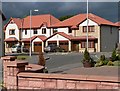
New housing on the western edge of Perth
A lot of new houses have been built on this side of Perth in recent years.
Image: © Rob Burke
Taken: 19 Jul 2005
0.13 miles
2
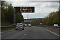
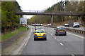
Perth : The A9
Heading along the A9 around Perth.
Image: © Lewis Clarke
Taken: 25 Apr 2016
0.14 miles

6
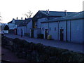
Noah's Ark, Perth
A kids play area beside the A9, with softplay, go-karts etc.
Image: © Mike Pennington
Taken: 31 Dec 2008
0.19 miles
7
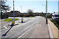
Hillend Road
Junction Viewlands Road West
Image: © A MELVILLE
Taken: 11 Apr 2020
0.20 miles
9
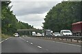
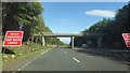
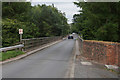
Bridge (Old Gallows Road) crossing the A9 to the west of Perth
Image: © David Dixon
Taken: 7 Apr 2017
0.21 miles
10
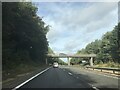
Bridge over the A9 at Perth
The bridge accesses Noah's Ark play centre, a caravan site and a driving range.
Image: © Mike Pennington
Taken: 7 Aug 2013
0.21 miles