IMAGES TAKEN NEAR TO
Tibbermore, PERTH, PH1 1QH
Introduction
This page details the photographs taken nearby to PH1 1QH by members of the Geograph project.
The Geograph project started in 2005 with the aim of publishing, organising and preserving representative images for every square kilometre of Great Britain, Ireland and the Isle of Man.

There are currently over 7.5m images from over14,400 individuals and you can help contribute to the project by visiting https://www.geograph.org.uk
Image Map
Images are licensed for reuse under creativecommons.org/licenses/by-sa/2.0
Notes
- Clicking on the map will re-center to the selected point.
- The higher the marker number, the further away the image location is from the centre of the postcode.
Image Listing (9 Images Found)
Images are licensed for reuse under creativecommons.org/licenses/by-sa/2.0
Image
Details
Distance
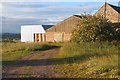
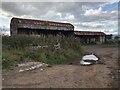
4
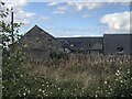
Easter Cultmalundie
Unused older steadings.
Image: © Richard Webb
Taken: 12 Sep 2023
0.05 miles
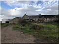
5
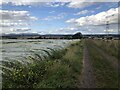
Track, Cultmalundie
A signposted route between Easter Cultmalundie and Mains of Cultmalundie.
Image: © Richard Webb
Taken: 12 Sep 2023
0.07 miles
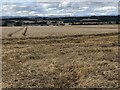
8

Spotlight on the landscape at Cultmalundie
Image: © Alan Reid
Taken: 6 Jul 2017
0.16 miles