IMAGES TAKEN NEAR TO
Jeanfield Road, PERTH, PH1 1PG
Introduction
This page details the photographs taken nearby to Jeanfield Road, PH1 1PG by members of the Geograph project.
The Geograph project started in 2005 with the aim of publishing, organising and preserving representative images for every square kilometre of Great Britain, Ireland and the Isle of Man.

There are currently over 7.5m images from over14,400 individuals and you can help contribute to the project by visiting https://www.geograph.org.uk
Image Map
Images are licensed for reuse under creativecommons.org/licenses/by-sa/2.0
Notes
- Clicking on the map will re-center to the selected point.
- The higher the marker number, the further away the image location is from the centre of the postcode.
Image Listing (28 Images Found)
Images are licensed for reuse under creativecommons.org/licenses/by-sa/2.0
Image
Details
Distance
1
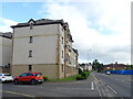
East on Jeanfield Road, Perth, New Year 1979
Dusk gathers, early afternoon at the turn of the year. 36-ish years later, StreetView shows that the building with the wee cupola, centre, has gone; the site is grass and bushes but the row of lime trees is still there. The building on the right is a tall two-storey stone affair with a prominent fire escape stair on the west side. A couple of cars are parked at the front behind an untended front garden in which is a sign headed 'Scottish Executive'. At the left edge of the photo are three-storey stone-built houses or flats. The evergreen trees beyond them are at the entrance to Perth Cemetery. Satellite photos suggest that Perth has changed a lot but maybe I didn't get to know the town well. Certainly, the prominent building with the chimney, left, cannot be found on aerial photos. Across the River Tay, Kinnoull Hill catches the sun in Image
Thanks to Tam for suggesting Jeanfield Road as the location.
Scanned from a Kodak Ektachrome 200 slide, ref 78·21·06 (year, film, frame), cleaned up, straightened and lightened.
Image: © Robin Stott
Taken: 1 Jan 1979
0.02 miles
2
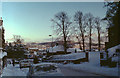
It was fifty years ago today
This was my birthplace, taken on my 50th birthday. The house stood where the lamp post and barrier is. It is at the junction of Longcauseway and Riggs Road in Perth.
Image: © william
Taken: 10 Sep 2011
0.07 miles
3
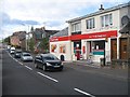
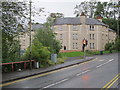
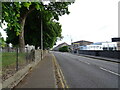
Convenience store, Jeanfield Road
Residential area in Perth, near the Royal Infirmary.
Image: © Richard Webb
Taken: 25 Sep 2009
0.12 miles
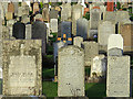
5
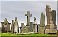
Wellshill cemetery
Gravestones in Wellshill cemetery, some unstable and near to collapse.
Image: © William Starkey
Taken: 10 Dec 2013
0.12 miles
8

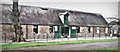
Perth fire station
Perth fire station, 401 High Street, Perth, Tayside
Image: © Kevin Hale
Taken: 31 Jul 2010
0.17 miles
9
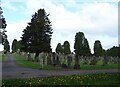
Gravestones, Wellshill cemetery
Gravestones at Wellshill cemetery in Perth, which dates from the 1840s.
Image: © William Starkey
Taken: 10 Dec 2013
0.17 miles