IMAGES TAKEN NEAR TO
Elm Gardens, PERTH, PH1 1ES
Introduction
This page details the photographs taken nearby to Elm Gardens, PH1 1ES by members of the Geograph project.
The Geograph project started in 2005 with the aim of publishing, organising and preserving representative images for every square kilometre of Great Britain, Ireland and the Isle of Man.

There are currently over 7.5m images from over14,400 individuals and you can help contribute to the project by visiting https://www.geograph.org.uk
Image Map
Images are licensed for reuse under creativecommons.org/licenses/by-sa/2.0
Notes
- Clicking on the map will re-center to the selected point.
- The higher the marker number, the further away the image location is from the centre of the postcode.
Image Listing (10 Images Found)
Images are licensed for reuse under creativecommons.org/licenses/by-sa/2.0
Image
Details
Distance
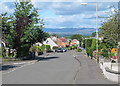
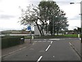
1
Viewlands Road West
A hilltop, Burghmuir, Perth. There are covered reservoirs behind the leylandii.
Image: © Richard Webb
Taken: 15 Dec 2016
0.09 miles
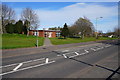
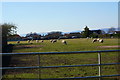
4

Viewlands Road West
Public open land beside Viewlands Road West, opposite Perth High School.
Image: © Richard Webb
Taken: 25 Sep 2009
0.14 miles
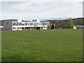
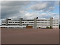
5
Perth High School from Newlands Road West
Image: © Mike Pennington
Taken: 9 Apr 2014
0.15 miles
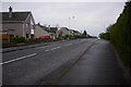
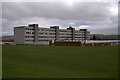
6
Muirend Gardens
Muirend Gardens meets Viewlands Road West. Perth High School on the other side.
Image: © Richard Webb
Taken: 25 Sep 2009
0.16 miles