IMAGES TAKEN NEAR TO
Braeside Gardens, PERTH, PH1 1DB
Introduction
This page details the photographs taken nearby to Braeside Gardens, PH1 1DB by members of the Geograph project.
The Geograph project started in 2005 with the aim of publishing, organising and preserving representative images for every square kilometre of Great Britain, Ireland and the Isle of Man.

There are currently over 7.5m images from over14,400 individuals and you can help contribute to the project by visiting https://www.geograph.org.uk
Image Map (Loading...)


Getting Data...Please wait
Leaflet Map data © OpenStreetMap
Images are licensed for reuse under creativecommons.org/licenses/by-sa/2.0
Notes
- Clicking on the map will re-center to the selected point.
- The higher the marker number, the further away the image location is from the centre of the postcode.
Image Listing (17 Images Found)
Images are licensed for reuse under creativecommons.org/licenses/by-sa/2.0
Image
Details
Distance
1
Fraser Terrace
Fraser Terrace, a residential area situated to the west of the city of Perth.
Image: © William Starkey
Taken: 25 Jul 2014
0.06 miles
2
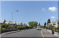
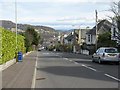
Murray Place, Perth
Looking towards Kinnoull Hill.
Image: © Mike Pennington
Taken: 9 Apr 2014
0.12 miles
3
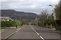
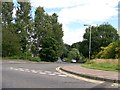
Glasgow Road, Cherrybank
The A93 (Glasgow Road) passing the Cherrybank Inn.
Image: © David Dixon
Taken: 27 Oct 2011
0.13 miles
4
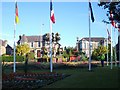
Floral display
6 o'clock on a weekday morning and the flowers are getting a good watering while they are still in the shade. This display is at the junction of Needless Road and Glasgow Road; the sunlit houses in the background are on Glasgow Road.
Image: © Lis Burke
Taken: 20 Jun 2006
0.13 miles
5
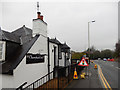
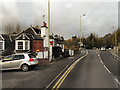
Cherrybank Inn, Cherrybank
This establishment on Glasgow Road in the Perth suburbs is an 18th century drovers' inn; today it offers a bar, restaurant and seven rooms.
Image: © Stephen McKay
Taken: 6 Apr 2019
0.14 miles
6
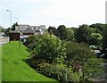
Cherrybank
On the left, the Glasgow Road. On the right below it, Low Road. The Cherrybank Inn is built on the slope between the two roads with its car park at the lower level.
Image: © Lis Burke
Taken: 22 Aug 2007
0.14 miles
10
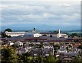
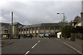
Perth Academy
Perth Academy is the white building with the central clock tower. The lower red brick buildings in front are Viewlands Primary School.
Between them they straddle the corners of four squares, but they seem to take up more space on this square than the others. This picture was taken from outside the office buildings at NO098222.
Image: © Lis Burke
Taken: 14 Jun 2005
0.19 miles