IMAGES TAKEN NEAR TO
Glenisla, BLAIRGOWRIE, PH11 8QH
Introduction
This page details the photographs taken nearby to PH11 8QH by members of the Geograph project.
The Geograph project started in 2005 with the aim of publishing, organising and preserving representative images for every square kilometre of Great Britain, Ireland and the Isle of Man.

There are currently over 7.5m images from over14,400 individuals and you can help contribute to the project by visiting https://www.geograph.org.uk
Image Map
Images are licensed for reuse under creativecommons.org/licenses/by-sa/2.0
Notes
- Clicking on the map will re-center to the selected point.
- The higher the marker number, the further away the image location is from the centre of the postcode.
Image Listing (4 Images Found)
Images are licensed for reuse under creativecommons.org/licenses/by-sa/2.0
Image
Details
Distance
1

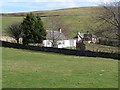
Access to Bellaty Farm
From B951. Farmhouse on left, steadings ahead.
Image: © Stanley Howe
Taken: 28 Jul 2016
0.02 miles
2

A Bellaty Cottage
The NW one of a pair; seen from the B951.
Image: © Stanley Howe
Taken: 28 Jul 2016
0.08 miles
4
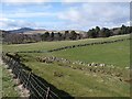
View up Glen Isla from Bellaty
Mount Blair Image on the skyline.
Image: © Oliver Dixon
Taken: 17 Mar 2012
0.23 miles