IMAGES TAKEN NEAR TO
Glenisla, BLAIRGOWRIE, PH11 8PS
Introduction
This page details the photographs taken nearby to PH11 8PS by members of the Geograph project.
The Geograph project started in 2005 with the aim of publishing, organising and preserving representative images for every square kilometre of Great Britain, Ireland and the Isle of Man.

There are currently over 7.5m images from over14,400 individuals and you can help contribute to the project by visiting https://www.geograph.org.uk
Image Map
Images are licensed for reuse under creativecommons.org/licenses/by-sa/2.0
Notes
- Clicking on the map will re-center to the selected point.
- The higher the marker number, the further away the image location is from the centre of the postcode.
Image Listing (10 Images Found)
Images are licensed for reuse under creativecommons.org/licenses/by-sa/2.0
Image
Details
Distance
1
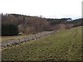
Holm of Needs
A pass allowing access to upper Glen Isla.
Image: © Richard Webb
Taken: 10 Mar 2007
0.06 miles
2
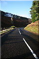
Bend on the B951 near Dykend
The road enters a gully (Holm of Needs) here.
Image: © Dan
Taken: 17 Jan 2009
0.11 miles
3
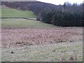
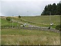
Wetland, Dykend
An area of wetland in an otherwise dry valley near Holm of Needs, a pass between Hill of Bellaty and the outlier Craiglea Hill. The lower slopes of Craiglea Hill can also be seen.
Image: © Richard Webb
Taken: 10 Mar 2007
0.18 miles
4
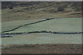
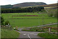
Fields at Dykend
Out with the 4WD checking drystane dykes on Nether Scithie Farm.
Image: © Mike Pennington
Taken: 2 Jan 2009
0.20 miles
5
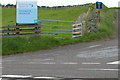
Sign depicting Scottish water, Backwater Reservoir
The road to the reservoir is straight ahead where the sign shows 'No Through Road'
Image: © Alan Morrison
Taken: 28 May 2009
0.21 miles
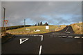
6
Crossroads, Dykend
The B951/B954 junction with a yellow road for Blackwater Reservoir.
Image: © Richard Webb
Taken: 16 Sep 2015
0.23 miles
8

North end of the B954
The termination of the B954 at the B951 junction. The Backwater Dam road is straight ahead.
Image: © Scott Cormie
Taken: 30 Jul 2017
0.23 miles
9
Backwater Reservoir / Alyth Road (B954) at its junction with Glenisla ./ Kirriemuir Road (B951)
Picture taken looking south.
Image: © Alan Morrison
Taken: 28 May 2009
0.24 miles
10
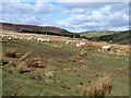
Sheep in the valley of the Back Water
The dam of the Backwater Reservoir Image can be seen in the middle distance.
Image: © Oliver Dixon
Taken: 17 Mar 2012
0.24 miles