IMAGES TAKEN NEAR TO
Glenisla, BLAIRGOWRIE, PH11 8PJ
Introduction
This page details the photographs taken nearby to PH11 8PJ by members of the Geograph project.
The Geograph project started in 2005 with the aim of publishing, organising and preserving representative images for every square kilometre of Great Britain, Ireland and the Isle of Man.

There are currently over 7.5m images from over14,400 individuals and you can help contribute to the project by visiting https://www.geograph.org.uk
Image Map
Images are licensed for reuse under creativecommons.org/licenses/by-sa/2.0
Notes
- Clicking on the map will re-center to the selected point.
- The higher the marker number, the further away the image location is from the centre of the postcode.
Image Listing (4 Images Found)
Images are licensed for reuse under creativecommons.org/licenses/by-sa/2.0
Image
Details
Distance
2
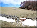
Fields near Doonies
The moles have been busy in the fields and an old bath has been used as a water trough. Recent snow has drifted against the stone walls.
Image: © Maigheach-gheal
Taken: 1 Apr 2010
0.22 miles
3

View towards summit of Mt Blair (744m)
From Brewlands Bridge (B951).
Image: © Stanley Howe
Taken: 28 Jul 2016
0.23 miles
4

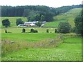
Fields near Clacknockater
Cattle pastures in upper Glen Isla.
Image: © Richard Webb
Taken: 20 Aug 2006
0.24 miles