IMAGES TAKEN NEAR TO
Glenisla, BLAIRGOWRIE, PH11 8PH
Introduction
This page details the photographs taken nearby to PH11 8PH by members of the Geograph project.
The Geograph project started in 2005 with the aim of publishing, organising and preserving representative images for every square kilometre of Great Britain, Ireland and the Isle of Man.

There are currently over 7.5m images from over14,400 individuals and you can help contribute to the project by visiting https://www.geograph.org.uk
Image Map
Images are licensed for reuse under creativecommons.org/licenses/by-sa/2.0
Notes
- Clicking on the map will re-center to the selected point.
- The higher the marker number, the further away the image location is from the centre of the postcode.
Image Listing (24 Images Found)
Images are licensed for reuse under creativecommons.org/licenses/by-sa/2.0
Image
Details
Distance
1
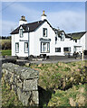
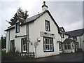
Glenisla Hotel
The Glenisla Hotel in Kirkton of Glenisla viewed across the minor stream, Kirkton Burn.
Image: © Trevor Littlewood
Taken: 10 Apr 2022
0.09 miles
2
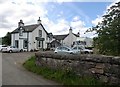
Glenisla Hotel, Kirkton of Glenisla
By B951.
Image: © Stanley Howe
Taken: 28 Jul 2016
0.10 miles
3
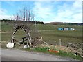
Willow arch, Kirkton of Glenisla
Immediately opposite the Glen Isla Hotel.
Image: © Oliver Dixon
Taken: 17 Mar 2012
0.10 miles
5
The Glenisla Hotel
Now the only hotel in the village. The Hotel across the road is now a private house.
Image: © Gwen and James Anderson
Taken: 2 Jul 2007
0.11 miles
6
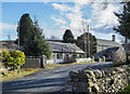
Glebe Cottage
Glebe Cottage in the small settlement of Kirkton of Glenisla is used currently as a holiday let. Previously the building has been in use as the village shop; see Richard Webb's image from 2005 - https://www.geograph.org.uk/photo/19457 .
Image: © Trevor Littlewood
Taken: 9 Apr 2022
0.11 miles
7
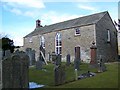
Parish Church, Kirkton of Glenisla
The present church was built in 1821 and is a small oblong Gothic building with belfry and session house. It is in a lovely rural setting.
Image: © Maigheach-gheal
Taken: 1 Apr 2010
0.12 miles
8
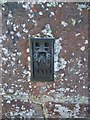
Flush Bracket G848, Kirkton of Glenisla
The flush bracket is to be found on the parish church. For a view of the church Image and http://www.bench-marks.org.uk/bm11642
A bench mark is an Ordnance Survey arrowhead sign found on walls, bridges, churches and specially erected triangulation pillars where the altitude above sea-level has been accurately measured by surveyors. The arrowhead points to a horizontal line above it which marks the exact altitude.
With rivets and pivots there is no datum (horizontal line) cut, the pointed-to horizontal surface defining the datum height.
Image: © Maigheach-gheal
Taken: 1 Apr 2010
0.12 miles
9
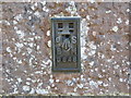
Ordnance Survey Flush Bracket G848
This can be found on the wall of Kirton of Glenisla Parish Kirk. The benchmark's recorded height is 246.407 metres above sea level.
For more detail see : https://www.bench-marks.org.uk/bm11642
Image: © Peter Wood
Taken: 27 Jun 2019
0.12 miles
10
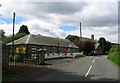
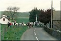
Kirkton of Glen Isla
Small village serving the scattered settlements of upper Glen Isla. Behind the camera is the pub, in the picture the shop and kirk. Shop was shut when I called in.
Image: © Richard Webb
Taken: 17 Jun 2005
0.12 miles