IMAGES TAKEN NEAR TO
Glenisla, BLAIRGOWRIE, PH11 8PF
Introduction
This page details the photographs taken nearby to PH11 8PF by members of the Geograph project.
The Geograph project started in 2005 with the aim of publishing, organising and preserving representative images for every square kilometre of Great Britain, Ireland and the Isle of Man.

There are currently over 7.5m images from over14,400 individuals and you can help contribute to the project by visiting https://www.geograph.org.uk
Image Map
Images are licensed for reuse under creativecommons.org/licenses/by-sa/2.0
Notes
- Clicking on the map will re-center to the selected point.
- The higher the marker number, the further away the image location is from the centre of the postcode.
Image Listing (4 Images Found)
Images are licensed for reuse under creativecommons.org/licenses/by-sa/2.0
Image
Details
Distance
1
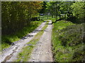
Farm track
This forms part of the Cateran Trail.
Image: © James Allan
Taken: 4 Jun 2012
0.18 miles
2
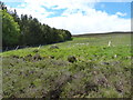
Edge of the wood
Conifer plantation north of Cammock farm.
Image: © James Allan
Taken: 4 Jun 2012
0.19 miles
3
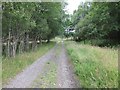
Cateran Trail at Cammock
The Cateran Trail heading southwards between the Kirkton of Glenisla and Kilry at Cammock.
Image: © Scott Cormie
Taken: 15 Jul 2018
0.20 miles
4
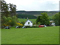
Whitehills farm
Between the Cateran Train and the river Isla.
Image: © James Allan
Taken: 4 Jun 2012
0.20 miles