IMAGES TAKEN NEAR TO
Alyth, BLAIRGOWRIE, PH11 8NA
Introduction
This page details the photographs taken nearby to PH11 8NA by members of the Geograph project.
The Geograph project started in 2005 with the aim of publishing, organising and preserving representative images for every square kilometre of Great Britain, Ireland and the Isle of Man.

There are currently over 7.5m images from over14,400 individuals and you can help contribute to the project by visiting https://www.geograph.org.uk
Image Map
Images are licensed for reuse under creativecommons.org/licenses/by-sa/2.0
Notes
- Clicking on the map will re-center to the selected point.
- The higher the marker number, the further away the image location is from the centre of the postcode.
Image Listing (7 Images Found)
Images are licensed for reuse under creativecommons.org/licenses/by-sa/2.0
Image
Details
Distance
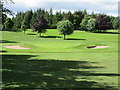
3
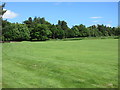
Alyth Golf Course, 6th hole
The sixth hole at Alyth looking to the green.
Image: © Scott Cormie
Taken: 18 Jun 2017
0.16 miles
4
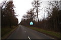
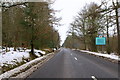
Alyth to Kirriemuir Road at County Boundary
Boundary between Angus and Perth and Kinross.
Image: © Sylvia Barrow
Taken: 19 Apr 2006
0.17 miles
5
Alyth Golf Course, 7th hole
The short downhill seventh hole at Alyth looking to the green over the ditch.
Image: © Scott Cormie
Taken: 18 Jun 2017
0.19 miles
6
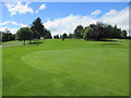
Alyth Golf Course, 2nd hole
The second hole at Alyth from behind the green.
Image: © Scott Cormie
Taken: 18 Jun 2017
0.21 miles
7
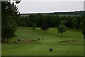
Alyth Golf Course
One of five courses around Blairgowrie and Alyth.
Image: © Mike Pennington
Taken: 19 Jul 2008
0.24 miles