IMAGES TAKEN NEAR TO
Alyth, BLAIRGOWRIE, PH11 8LU
Introduction
This page details the photographs taken nearby to PH11 8LU by members of the Geograph project.
The Geograph project started in 2005 with the aim of publishing, organising and preserving representative images for every square kilometre of Great Britain, Ireland and the Isle of Man.

There are currently over 7.5m images from over14,400 individuals and you can help contribute to the project by visiting https://www.geograph.org.uk
Image Map
Images are licensed for reuse under creativecommons.org/licenses/by-sa/2.0
Notes
- Clicking on the map will re-center to the selected point.
- The higher the marker number, the further away the image location is from the centre of the postcode.
Image Listing (2 Images Found)
Images are licensed for reuse under creativecommons.org/licenses/by-sa/2.0
Image
Details
Distance
1
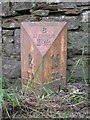
Old Milepost by the B954, Alyth Parish
Perth by the B954, in parish of Alyth (District), near minor road to Netherton, on verge.
Inscription reads:- : 2 / TO / ALYTH : : Co.ANGUS / 6 /MEIGLE / 1¾ : : 15 / TO / DUNDEE :
Surveyed
Milestone Society National ID: PK_ALDD02
Image: © Milestone Society
Taken: Unknown
0.18 miles
2
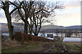
Fields above West Jordanstone
The flooded Isla is in the background.
Image: © Mike Pennington
Taken: 23 Dec 2012
0.24 miles