IMAGES TAKEN NEAR TO
Alyth, BLAIRGOWRIE, PH11 8LJ
Introduction
This page details the photographs taken nearby to PH11 8LJ by members of the Geograph project.
The Geograph project started in 2005 with the aim of publishing, organising and preserving representative images for every square kilometre of Great Britain, Ireland and the Isle of Man.

There are currently over 7.5m images from over14,400 individuals and you can help contribute to the project by visiting https://www.geograph.org.uk
Image Map
Images are licensed for reuse under creativecommons.org/licenses/by-sa/2.0
Notes
- Clicking on the map will re-center to the selected point.
- The higher the marker number, the further away the image location is from the centre of the postcode.
Image Listing (25 Images Found)
Images are licensed for reuse under creativecommons.org/licenses/by-sa/2.0
Image
Details
Distance
1
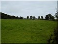
Rosebank, Alyth
Farmhouse on the southern slopes of the Hill of Alyth.
Image: © Mike Pennington
Taken: 1 Jan 2009
0.01 miles
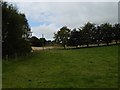
2
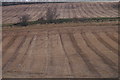
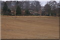
Fields on the Hill of Alyth
Stubble on the southern slopes of the Hill of Alyth.
Image: © Mike Pennington
Taken: 1 Jan 2009
0.11 miles
4
Behind Alyth
Looking along the Back Burn at the southern foot of Hill of Alyth.
Image: © Richard Webb
Taken: 16 Sep 2015
0.13 miles
5
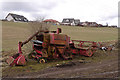
Abandoned combine harvester
Clearly this one will not be used again.
Image: © Rob Burke
Taken: 3 Apr 2010
0.13 miles
6
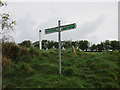
Cateran Trail signpost
Signpost on the Cateran Trail just north of Alyth.
Image: © Scott Cormie
Taken: 21 May 2017
0.14 miles
7
Location of OS Cut Mark - Alyth, The Brae
Image: © thejackrustles
Taken: 11 Jun 2024
0.17 miles
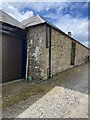
8
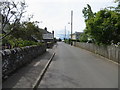
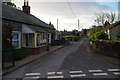
Loyal Road in Alyth
Looking south-westward.
Image: © Peter Wood
Taken: 25 Jun 2019
0.17 miles