IMAGES TAKEN NEAR TO
Alyth, BLAIRGOWRIE, PH11 8JU
Introduction
This page details the photographs taken nearby to PH11 8JU by members of the Geograph project.
The Geograph project started in 2005 with the aim of publishing, organising and preserving representative images for every square kilometre of Great Britain, Ireland and the Isle of Man.

There are currently over 7.5m images from over14,400 individuals and you can help contribute to the project by visiting https://www.geograph.org.uk
Image Map
Images are licensed for reuse under creativecommons.org/licenses/by-sa/2.0
Notes
- Clicking on the map will re-center to the selected point.
- The higher the marker number, the further away the image location is from the centre of the postcode.
Image Listing (6 Images Found)
Images are licensed for reuse under creativecommons.org/licenses/by-sa/2.0
Image
Details
Distance
1
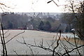
Dillavaird, near Airlie
Beside the River Isla.
Image: © Mike Pennington
Taken: 1 Jan 2009
0.06 miles
2
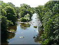
River Isla downstream from Bridge of Dillavaird
Image: © Russel Wills
Taken: 4 Jul 2009
0.15 miles
3

View from the bridge over the Isla below Den of Airlie
Image: © Mike Pennington
Taken: 4 Aug 2007
0.17 miles
4
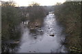
River Isla below Den of Airlie in winter
Image: © Mike Pennington
Taken: 1 Jan 2009
0.21 miles
5
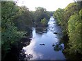
River Isla, Bridge of Dillavaird
The River Isla rises on the border between Angus and Aberdeenshire and after 46 miles it joins the River Tay at Cargill. Looking downstream.
Image: © Maigheach-gheal
Taken: 7 Oct 2009
0.22 miles
6
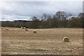
Round bales Dillavaird
Beside the River Isla where it emerges from the Den of Airlie.
Image: © Richard Webb
Taken: 29 Mar 2015
0.22 miles