IMAGES TAKEN NEAR TO
Kilry, BLAIRGOWRIE, PH11 8HY
Introduction
This page details the photographs taken nearby to PH11 8HY by members of the Geograph project.
The Geograph project started in 2005 with the aim of publishing, organising and preserving representative images for every square kilometre of Great Britain, Ireland and the Isle of Man.

There are currently over 7.5m images from over14,400 individuals and you can help contribute to the project by visiting https://www.geograph.org.uk
Image Map
Images are licensed for reuse under creativecommons.org/licenses/by-sa/2.0
Notes
- Clicking on the map will re-center to the selected point.
- The higher the marker number, the further away the image location is from the centre of the postcode.
Image Listing (4 Images Found)
Images are licensed for reuse under creativecommons.org/licenses/by-sa/2.0
Image
Details
Distance
1
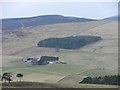
Nether Drumhead
Nether Drumhead with moors and forests of the Forest of Alyth. View from Balduff Hill.
Image: © Richard Webb
Taken: 6 Mar 2011
0.10 miles
2
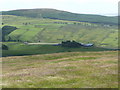
Nether Drumhead across the pasture
The half gale was rippling the grass in the foreground.
Image: © Russel Wills
Taken: 7 Jul 2010
0.11 miles
3
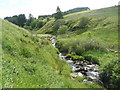
Burn of Watersheal
Below Nether Drumhead farm.
Image: © Russel Wills
Taken: 7 Jul 2010
0.17 miles
4
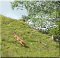
Roe deer
This deer was grazing beside the burn and unaware of my approach but soon took off up the hill.
Image: © Russel Wills
Taken: 7 Jul 2010
0.22 miles