IMAGES TAKEN NEAR TO
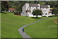
High Street, BLAIRGOWRIE, PH10 7RE
Introduction
This page details the photographs taken nearby to High Street, PH10 7RE by members of the Geograph project.
The Geograph project started in 2005 with the aim of publishing, organising and preserving representative images for every square kilometre of Great Britain, Ireland and the Isle of Man.

There are currently over 7.5m images from over14,400 individuals and you can help contribute to the project by visiting https://www.geograph.org.uk
Image Map
Images are licensed for reuse under creativecommons.org/licenses/by-sa/2.0
Notes
- Clicking on the map will re-center to the selected point.
- The higher the marker number, the further away the image location is from the centre of the postcode.
Image Listing (81 Images Found)
Images are licensed for reuse under creativecommons.org/licenses/by-sa/2.0
Image
Details
Distance
1
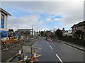
High Street, Rattray
Construction in progress by the school.
Image: © Richard Webb
Taken: 22 Feb 2014
0.01 miles
2
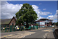
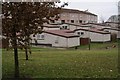
Rattray Primary School
The extension being built to the right will house a new gym hall, amongst other uses.
Image: © Mike Pennington
Taken: 4 Aug 2013
0.03 miles
3
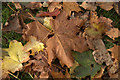
Fallen sycamore leaves beside Rattray Primary School
Image: © Mike Pennington
Taken: 17 Oct 2013
0.08 miles
4
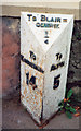
Old Milepost by the A926, High Street, Rattray
Perth milepost by the A926, in parish of Rattray (Perth and Kinross District), Rattray, on footpath, by wall with railings.
Inscription reads:-
: TO / KIRRIEMUIR / 14 : : To BLAIR= / GOWRIE / ¼ : : TO / ALYTH / 5 :
Surveyed
Milestone Society National ID: PK_BGKR00
Image: © Milestone Society
Taken: Unknown
0.10 miles
6
Ferguson Park
A modern scheme, one of two (along with Davie Park) which saw a considerable increase in the population of Rattray; known locally as Fergie Park.
Image: © Mike Pennington
Taken: 10 Feb 2008
0.13 miles
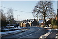
7
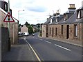
The Cross, Rattray
The main A926 road in from the east.
Image: © Oliver Dixon
Taken: 11 Aug 2013
0.13 miles
8
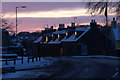
High Street, Rattray
The very eastern end of the road, just as before it becomes Alyth Road, with old cottages along the roadside, and the setting sun reflecting in the windows.
Image: © Mike Pennington
Taken: 23 Dec 2009
0.15 miles
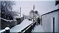
9
The Old Cross, Rattray, Christmas Day
This crossroads in what is now known as Old Rattray, was presumably the centre of the village. It is where Alyth Road, High Street, Parkhill Road and Kirkton Road meet, but the sideroads are little used these days, as reflected in the name, Old Cross.
Image: © Mike Pennington
Taken: 25 Dec 2009
0.16 miles
10
Farview Holiday Cottage
Taken on Christmas Day 2005. For further information on the 150-year-old cottage see http://www.farviewcottage.com/.
Image: © Jane McAulay
Taken: 25 Dec 2005
0.16 miles