IMAGES TAKEN NEAR TO
Ballintuim, BLAIRGOWRIE, PH10 7PX
Introduction
This page details the photographs taken nearby to PH10 7PX by members of the Geograph project.
The Geograph project started in 2005 with the aim of publishing, organising and preserving representative images for every square kilometre of Great Britain, Ireland and the Isle of Man.

There are currently over 7.5m images from over14,400 individuals and you can help contribute to the project by visiting https://www.geograph.org.uk
Image Map
Images are licensed for reuse under creativecommons.org/licenses/by-sa/2.0
Notes
- Clicking on the map will re-center to the selected point.
- The higher the marker number, the further away the image location is from the centre of the postcode.
Image Listing (5 Images Found)
Images are licensed for reuse under creativecommons.org/licenses/by-sa/2.0
Image
Details
Distance
1
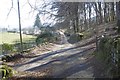
Blackcraig
A road junction beneath Blackcraig Forest.
Image: © Richard Webb
Taken: 25 Mar 2017
0.07 miles
2
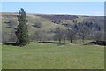
Field, Blackcraig
Farmland in Strath Ardle.
Image: © Richard Webb
Taken: 25 Mar 2017
0.13 miles
3
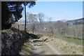
Road on the edge of Blackcraig Forest
The road accesses houses and farm buildings on the west side of the Ardle. There is a good example of an old stone wall here on the woodland side.
Image: © Richard Webb
Taken: 25 Mar 2017
0.15 miles
4
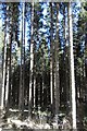
Blackraig Forest
There are a lot more older conifers in Blackcraig than in most plantations.
Image: © Richard Webb
Taken: 25 Mar 2017
0.25 miles
5
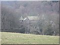
Blackcraig Castle
With a baronial "castle" for a bridge.
Image: © Richard Webb
Taken: 24 Feb 2007
0.25 miles