IMAGES TAKEN NEAR TO
Kirkmichael, BLAIRGOWRIE, PH10 7NA
Introduction
This page details the photographs taken nearby to PH10 7NA by members of the Geograph project.
The Geograph project started in 2005 with the aim of publishing, organising and preserving representative images for every square kilometre of Great Britain, Ireland and the Isle of Man.

There are currently over 7.5m images from over14,400 individuals and you can help contribute to the project by visiting https://www.geograph.org.uk
Image Map
Images are licensed for reuse under creativecommons.org/licenses/by-sa/2.0
Notes
- Clicking on the map will re-center to the selected point.
- The higher the marker number, the further away the image location is from the centre of the postcode.
Image Listing (3 Images Found)
Images are licensed for reuse under creativecommons.org/licenses/by-sa/2.0
Image
Details
Distance
1
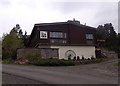
Log Cabin Hotel, Kirkmichael
End of public road, out of village to the east.
Image: © Stanley Howe
Taken: 15 May 2014
0.06 miles
2
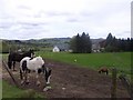
Horse paddock, Middle Balnald
On the road from Log Cabin Hotel to Kirkmichael bridge.
Image: © Stanley Howe
Taken: 15 May 2014
0.17 miles
3
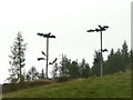
Etiolated baobab trees
An unusual growth in Strathardle.
Image: © Russel Wills
Taken: 21 Sep 2009
0.20 miles