IMAGES TAKEN NEAR TO
Kirkmichael, BLAIRGOWRIE, PH10 7LU
Introduction
This page details the photographs taken nearby to PH10 7LU by members of the Geograph project.
The Geograph project started in 2005 with the aim of publishing, organising and preserving representative images for every square kilometre of Great Britain, Ireland and the Isle of Man.

There are currently over 7.5m images from over14,400 individuals and you can help contribute to the project by visiting https://www.geograph.org.uk
Image Map
Images are licensed for reuse under creativecommons.org/licenses/by-sa/2.0
Notes
- Clicking on the map will re-center to the selected point.
- The higher the marker number, the further away the image location is from the centre of the postcode.
Image Listing (5 Images Found)
Images are licensed for reuse under creativecommons.org/licenses/by-sa/2.0
Image
Details
Distance
1
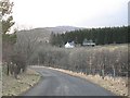
The Kirkmichael - Dalrulzion road
Almost a single track road running through wet farmland and alder carrs.
Image: © Richard Webb
Taken: 24 Feb 2008
0.01 miles
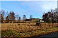
3
Tonloid, a renovated/enlarged croft
Seen from the B950.
Image: © Stanley Howe
Taken: 15 May 2014
0.02 miles
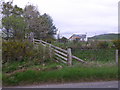
4

View over the valley of Dounie Burn, near Kirkmichael
Image: © Mike Pennington
Taken: 17 Jul 2011
0.12 miles
5
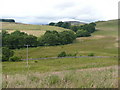
Trees follow the course of the Ashintully Burn
Under the slopes of Milton Knowe.
Image: © Russel Wills
Taken: 8 Aug 2009
0.25 miles