IMAGES TAKEN NEAR TO
Bridge Of Cally, BLAIRGOWRIE, PH10 7LQ
Introduction
This page details the photographs taken nearby to PH10 7LQ by members of the Geograph project.
The Geograph project started in 2005 with the aim of publishing, organising and preserving representative images for every square kilometre of Great Britain, Ireland and the Isle of Man.

There are currently over 7.5m images from over14,400 individuals and you can help contribute to the project by visiting https://www.geograph.org.uk
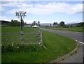
Image Map
Images are licensed for reuse under creativecommons.org/licenses/by-sa/2.0
Notes
- Clicking on the map will re-center to the selected point.
- The higher the marker number, the further away the image location is from the centre of the postcode.
Image Listing (5 Images Found)
Images are licensed for reuse under creativecommons.org/licenses/by-sa/2.0
Image
Details
Distance
1
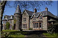
Persie House, Bridge of Cally, Blairgowrie.
Headquarters of Persie Estate which consists of farms and hill ground used for sporting activities. It also has fishing on the nearby River Blackwater. The house can be hired for corporate activities, weddings etc.
Image: © Ron Male
Taken: 6 May 2007
0.09 miles
2

Pasture and Mains of Persie
Hill of Persie on the horizon.
Image: © Russel Wills
Taken: 30 Jul 2010
0.11 miles
3
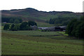
Mains of Persie
The Hill of Persie is in the background.
Image: © Mike Pennington
Taken: 17 Jul 2011
0.12 miles
4
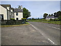
A93 heading north up Glenshee
Here from the access junction for Persie House; with the disused Persie Church ahead right.
Image: © Stanley Howe
Taken: 30 May 2013
0.24 miles