IMAGES TAKEN NEAR TO
Bridge Of Cally, BLAIRGOWRIE, PH10 7JW
Introduction
This page details the photographs taken nearby to PH10 7JW by members of the Geograph project.
The Geograph project started in 2005 with the aim of publishing, organising and preserving representative images for every square kilometre of Great Britain, Ireland and the Isle of Man.

There are currently over 7.5m images from over14,400 individuals and you can help contribute to the project by visiting https://www.geograph.org.uk
Image Map
Images are licensed for reuse under creativecommons.org/licenses/by-sa/2.0
Notes
- Clicking on the map will re-center to the selected point.
- The higher the marker number, the further away the image location is from the centre of the postcode.
Image Listing (8 Images Found)
Images are licensed for reuse under creativecommons.org/licenses/by-sa/2.0
Image
Details
Distance
1
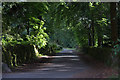
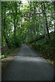
Road to Ashmore Farm, Bridge of Cally
Image: © Mike Pennington
Taken: 29 Jul 2010
0.06 miles
2
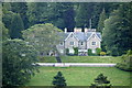
Ashmore House, Netherton
From across the valley of the Black Water.
Image: © Mike Pennington
Taken: 17 Jul 2011
0.08 miles
3
Road to Ashmore Farm, Bridge of Cally
Glen Ericht is in the distance.
Image: © Mike Pennington
Taken: 29 Jul 2010
0.09 miles
4
Road to Ashmore Farm, Bridge of Cally
Image: © Mike Pennington
Taken: 29 Jul 2010
0.10 miles
5
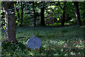
Satellite dish in the woods, Ashmore, Bridge of Cally
With the terrain in the area, finding a decent place for your dish is obviously tricky.
Image: © Mike Pennington
Taken: 29 Jul 2010
0.15 miles
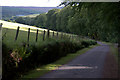
6
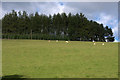
Pasture and shelterbelt, Ashmore, Bridge of Cally
Image: © Mike Pennington
Taken: 29 Jul 2010
0.19 miles
7
Road to Ashmore Farm, Bridge of Cally
Image: © Mike Pennington
Taken: 29 Jul 2010
0.24 miles
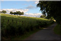
8
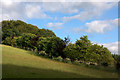
New shelterbelt, Ashmore, Bridge of Cally
Image: © Mike Pennington
Taken: 29 Jul 2010
0.24 miles