IMAGES TAKEN NEAR TO
Bridge Of Cally, BLAIRGOWRIE, PH10 7JH
Introduction
This page details the photographs taken nearby to PH10 7JH by members of the Geograph project.
The Geograph project started in 2005 with the aim of publishing, organising and preserving representative images for every square kilometre of Great Britain, Ireland and the Isle of Man.

There are currently over 7.5m images from over14,400 individuals and you can help contribute to the project by visiting https://www.geograph.org.uk
Image Map
Images are licensed for reuse under creativecommons.org/licenses/by-sa/2.0
Notes
- Clicking on the map will re-center to the selected point.
- The higher the marker number, the further away the image location is from the centre of the postcode.
Image Listing (4 Images Found)
Images are licensed for reuse under creativecommons.org/licenses/by-sa/2.0
Image
Details
Distance
2
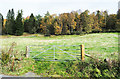
Sloping field beyond metal gate
The field rises above the A924 through Strathardle in the vicinity of the house / farm at Cally. At the time the exposure was made a deer was running along the field's upper edge, but it can't be spotted in the image!
Image: © Trevor Littlewood
Taken: 23 Oct 2018
0.17 miles
3
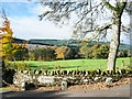
Dry stone wall with House name
The wall is beside the lodge at the A924 roadside access for the house or farm at Cally, not far from Bridge of Cally.
Image: © Trevor Littlewood
Taken: 23 Oct 2018
0.19 miles
4
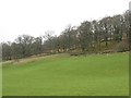
Side of Strathardle
Monk's Cally. The slopes above the fertile glen floor carry oak woods before becoming moorland at higher altitude. The hill here divides Strathardle and Glen Shee.
Image: © Richard Webb
Taken: 24 Feb 2007
0.23 miles