IMAGES TAKEN NEAR TO
Rattray, BLAIRGOWRIE, PH10 7JD
Introduction
This page details the photographs taken nearby to PH10 7JD by members of the Geograph project.
The Geograph project started in 2005 with the aim of publishing, organising and preserving representative images for every square kilometre of Great Britain, Ireland and the Isle of Man.

There are currently over 7.5m images from over14,400 individuals and you can help contribute to the project by visiting https://www.geograph.org.uk
Image Map
Images are licensed for reuse under creativecommons.org/licenses/by-sa/2.0
Notes
- Clicking on the map will re-center to the selected point.
- The higher the marker number, the further away the image location is from the centre of the postcode.
Image Listing (8 Images Found)
Images are licensed for reuse under creativecommons.org/licenses/by-sa/2.0
Image
Details
Distance
1
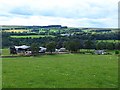
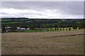
Middle Drimmie Farm
Home to the Glenericht herd of Charolais cattle. Glen Ericht lies beyond.
Image: © Oliver Dixon
Taken: 11 Aug 2013
0.05 miles
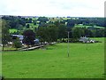
2

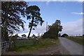
Middle Drimmie
Looking down on Middle Drimmie from the road to the north-east.
Image: © Scott Cormie
Taken: 22 Jul 2018
0.06 miles
3
Middle Drimmie Farm
Home to the Glenericht herd of Charolais cattle. Glen Ericht lies beyond.
Image: © Oliver Dixon
Taken: 11 Aug 2013
0.06 miles
4
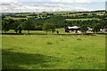
Middle Drimmie
The gorge of the River Ericht is in the trees.
Image: © Mike Pennington
Taken: 15 Jul 2008
0.07 miles
5
Middle Drimmie Farm
Spring Lambs in Drimmie
Image: © Sylvia Barrow
Taken: 30 Apr 2006
0.10 miles
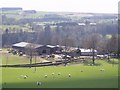
6
Middle Drimmie
Home of a herd of Charolais cattle.
Image: © Richard Webb
Taken: 29 Sep 2018
0.20 miles
7
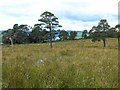
Middle Drimmie Wood
The sheep are in an area mapped as Middle Drimmie Wood. It is no longer wooded.
Image: © Richard Webb
Taken: 29 Sep 2018
0.24 miles
8
Middle Drimmie Wood
Whatever it was in the past, now a few scattered Scots Pines.
Image: © Oliver Dixon
Taken: 11 Aug 2013
0.25 miles