IMAGES TAKEN NEAR TO
Rattray, BLAIRGOWRIE, PH10 7HQ
Introduction
This page details the photographs taken nearby to PH10 7HQ by members of the Geograph project.
The Geograph project started in 2005 with the aim of publishing, organising and preserving representative images for every square kilometre of Great Britain, Ireland and the Isle of Man.

There are currently over 7.5m images from over14,400 individuals and you can help contribute to the project by visiting https://www.geograph.org.uk
Image Map
Images are licensed for reuse under creativecommons.org/licenses/by-sa/2.0
Notes
- Clicking on the map will re-center to the selected point.
- The higher the marker number, the further away the image location is from the centre of the postcode.
Image Listing (11 Images Found)
Images are licensed for reuse under creativecommons.org/licenses/by-sa/2.0
Image
Details
Distance
1
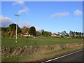
Pictfield
A small settlement to the north of the road between Blairgowrie and Alyth.
Image: © James Allan
Taken: 13 Nov 2006
0.06 miles
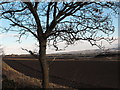
2
Polytunnel frames
A steep grass field and then back to the berries. Looking up from the A926.
Image: © Richard Webb
Taken: 22 Feb 2014
0.12 miles
3
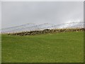
Wood, Pictfield
One of at least two sandy areas populated by rabbits on steep ground above the A926.
Image: © Richard Webb
Taken: 22 Feb 2014
0.13 miles
4
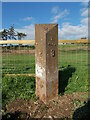
Old milepost
This post was discovered in 2021 when a trench on the verge of the A926 for services to a new house was being dug. It was probably toppled and covered over in 1940. Kirriemuir and Alyth are both to the east with Blairgowrie, on the bevel, 2¼ miles to the west. This milepost is typical of the milemarkers in this area but it is not known at which foundry they were cast.
Image: © John Riddell
Taken: 15 Oct 2021
0.15 miles
5
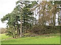
Wooded spur near Pictfield
Looks like a spoil heap but is probably a sandy deposit heavily mined by rabbits.
Image: © Richard Webb
Taken: 22 Feb 2014
0.16 miles
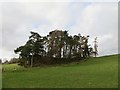
6
Woodland, Pictfield
A spur looks like a spoil heap but may well be a glacial deposit. Soils are light and there is evidence of many years of rabbit erosion.
Image: © Richard Webb
Taken: 22 Feb 2014
0.16 miles
7
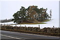
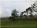
Small roundel of trees near Halfway House
Image: © Alan Morrison
Taken: 14 Feb 2009
0.16 miles
9
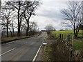
A926, Pictfield
Alyth to Rattray road - very twisty and rather hyperactive in the third dimension too.
Image: © Richard Webb
Taken: 22 Feb 2014
0.18 miles
10
Looking back towards Ardler and Meigle
Taken from the lay-by on the Alyth to Blairgowrie road.
Image: © Alison
Taken: 24 Jan 2009
0.21 miles