IMAGES TAKEN NEAR TO
Rattray, BLAIRGOWRIE, PH10 7HG
Introduction
This page details the photographs taken nearby to PH10 7HG by members of the Geograph project.
The Geograph project started in 2005 with the aim of publishing, organising and preserving representative images for every square kilometre of Great Britain, Ireland and the Isle of Man.

There are currently over 7.5m images from over14,400 individuals and you can help contribute to the project by visiting https://www.geograph.org.uk
Image Map
Images are licensed for reuse under creativecommons.org/licenses/by-sa/2.0
Notes
- Clicking on the map will re-center to the selected point.
- The higher the marker number, the further away the image location is from the centre of the postcode.
Image Listing (3 Images Found)
Images are licensed for reuse under creativecommons.org/licenses/by-sa/2.0
Image
Details
Distance
1
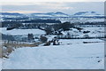
Rattray Castle
The earth embankment is a Motte fortification. The Sidlaw Hills are in the background.
Image: © Mike Pennington
Taken: 3 Jan 2010
0.06 miles
2
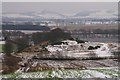
Rattray Castle
Only earth embankments remain.
Image: © Mike Pennington
Taken: 4 Jan 2008
0.07 miles
3
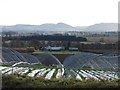
Polytunnels with a view
Looking south from Easter Rattray Farm across Strathmore towards the Sidlaw Hills through the arches formed by the polytunnel frames.
Image: © Ian Paterson
Taken: 23 Nov 2009
0.20 miles