IMAGES TAKEN NEAR TO
Rattray, BLAIRGOWRIE, PH10 7HD
Introduction
This page details the photographs taken nearby to PH10 7HD by members of the Geograph project.
The Geograph project started in 2005 with the aim of publishing, organising and preserving representative images for every square kilometre of Great Britain, Ireland and the Isle of Man.

There are currently over 7.5m images from over14,400 individuals and you can help contribute to the project by visiting https://www.geograph.org.uk
Image Map
Images are licensed for reuse under creativecommons.org/licenses/by-sa/2.0
Notes
- Clicking on the map will re-center to the selected point.
- The higher the marker number, the further away the image location is from the centre of the postcode.
Image Listing (11 Images Found)
Images are licensed for reuse under creativecommons.org/licenses/by-sa/2.0
Image
Details
Distance
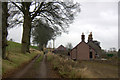
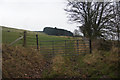
2
House at Easter Hatton
The hill beyond is Broad Moss.
Image: © Mike Pennington
Taken: 22 Oct 2006
0.02 miles
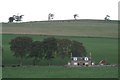
3
Easter Hatton from Blackhills
Just north of Rattray.
Image: © Mike Pennington
Taken: 15 Jul 2008
0.03 miles
5
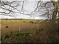
Sheep, Hatton
A flock of Herdwicks, some distance from the Lake District.
Image: © Richard Webb
Taken: 22 Feb 2014
0.16 miles
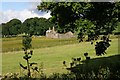
6
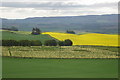
Field of flowering rhubarb
Field near Easter Hatton looking over Vale of Strathmore
Image: © Sylvia Barrow
Taken: 3 Jun 2006
0.18 miles
8
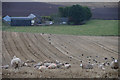
Sheep in stubble above Linksholm, Rattray
Image: © Mike Pennington
Taken: 5 Jan 2013
0.21 miles
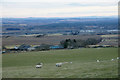
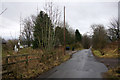
9
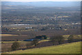
View to Blairgowrie from above Blackhills
The nearest farm is Linksholm.
Image: © Mike Pennington
Taken: 6 Apr 2013
0.21 miles