IMAGES TAKEN NEAR TO
Rattray, BLAIRGOWRIE, PH10 7HB
Introduction
This page details the photographs taken nearby to PH10 7HB by members of the Geograph project.
The Geograph project started in 2005 with the aim of publishing, organising and preserving representative images for every square kilometre of Great Britain, Ireland and the Isle of Man.

There are currently over 7.5m images from over14,400 individuals and you can help contribute to the project by visiting https://www.geograph.org.uk
Image Map
Images are licensed for reuse under creativecommons.org/licenses/by-sa/2.0
Notes
- Clicking on the map will re-center to the selected point.
- The higher the marker number, the further away the image location is from the centre of the postcode.
Image Listing (5 Images Found)
Images are licensed for reuse under creativecommons.org/licenses/by-sa/2.0
Image
Details
Distance
2
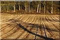
Stubble, Parkhill, Rattray
Looking across to the woodland around the house at Parkhill, where a few Roe Deer were lurking.
Image: © Mike Pennington
Taken: 1 Jan 2013
0.17 miles
3
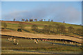
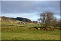
Sheep near Linksholm, Rattray
The hill in the background is Broad Moss.
Image: © Mike Pennington
Taken: 1 Jan 2013
0.18 miles
4
Quarry, Parkhill
Hillside workings, partly screened by trees.
Image: © Richard Webb
Taken: 22 Feb 2014
0.18 miles
5
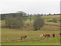
View to Easter Hatton from Parkhill, Rattray
Image: © Mike Pennington
Taken: 1 Jan 2014
0.19 miles