IMAGES TAKEN NEAR TO
Coralbank, BLAIRGOWRIE, PH10 7EN
Introduction
This page details the photographs taken nearby to Coralbank, PH10 7EN by members of the Geograph project.
The Geograph project started in 2005 with the aim of publishing, organising and preserving representative images for every square kilometre of Great Britain, Ireland and the Isle of Man.

There are currently over 7.5m images from over14,400 individuals and you can help contribute to the project by visiting https://www.geograph.org.uk
Image Map
Images are licensed for reuse under creativecommons.org/licenses/by-sa/2.0
Notes
- Clicking on the map will re-center to the selected point.
- The higher the marker number, the further away the image location is from the centre of the postcode.
Image Listing (86 Images Found)
Images are licensed for reuse under creativecommons.org/licenses/by-sa/2.0
Image
Details
Distance
1
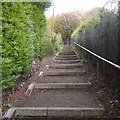
Steps, Rattray
A path connecting Hatton Road with Victoria Street. There are ramps for wheeling a bike, but these are often blocked by vegetation, either at ground level or protruding from the hedge.
Image: © Richard Webb
Taken: 29 Sep 2018
0.09 miles
2
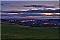
Blairgowrie at twilight from Bonnington
Image: © David Martin
Taken: 23 Dec 2008
0.10 miles
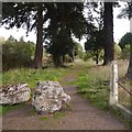
5
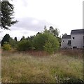
Unused ground, Hatton Road
Beside the remains of a driveway Image], these were the grounds of the Marfield, a closed pub which was demolished in 2008..
Image: © Richard Webb
Taken: 29 Sep 2018
0.12 miles
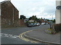
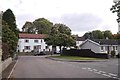
6
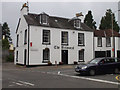
The Balmoral
The only remaining pub in Rattray, as the Old Cross Inn is now more of a restaurant.
Image: © Mike Pennington
Taken: 27 Jul 2008
0.13 miles
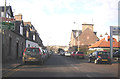
7
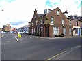
Main road junction in Rattray
Balmoral Road (A93) to the left, High Street, Rattry (A926) to the right.
Image: © Oliver Dixon
Taken: 11 Aug 2013
0.13 miles
9
Entrance to the Marfield, Hatton Road
There are the remains of a sign on one of the trees - once there was a back entrance to the Marfield pub, demolished in 2008.
Image: © Richard Webb
Taken: 29 Sep 2018
0.13 miles
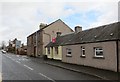
10
Victoria Street, Rattray
A dead end for motors, but there is a path out at the end of the rear right turn.
Image: © Richard Webb
Taken: 29 Sep 2018
0.13 miles