IMAGES TAKEN NEAR TO
Riverside Drive, BLAIRGOWRIE, PH10 7EH
Introduction
This page details the photographs taken nearby to Riverside Drive, PH10 7EH by members of the Geograph project.
The Geograph project started in 2005 with the aim of publishing, organising and preserving representative images for every square kilometre of Great Britain, Ireland and the Isle of Man.

There are currently over 7.5m images from over14,400 individuals and you can help contribute to the project by visiting https://www.geograph.org.uk
Image Map
Images are licensed for reuse under creativecommons.org/licenses/by-sa/2.0
Notes
- Clicking on the map will re-center to the selected point.
- The higher the marker number, the further away the image location is from the centre of the postcode.
Image Listing (203 Images Found)
Images are licensed for reuse under creativecommons.org/licenses/by-sa/2.0
Image
Details
Distance
1
The River Ericht
The River Ericht is formed at the meeting of the Black Water and the River Ardle, five miles north of Blairgowrie.
Image: © Maigheach-gheal
Taken: 3 Apr 2007
0.04 miles
2
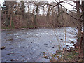
River Ericht at Blairgowrie
The River Ericht splits up Blairgowrie on the south and Ratray on the north.
Image: © Maigheach-gheal
Taken: 3 Apr 2007
0.05 miles
3
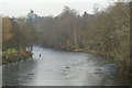
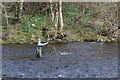
River Ericht
Looking north from the bridge linking Blairgowrie and Rattray; an angler tries his luck as the mid-day sun burns off morning mist.
Image: © Mike Pennington
Taken: 11 Feb 2008
0.05 miles
4
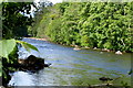
River Ericht at Blairgowrie
Picture taken looking upstream from Picnic Area north of Blairgowrie Bridge.
Image: © Alan Morrison
Taken: 28 May 2009
0.05 miles
5
Angler on the Ericht
At Blairgowrie.
Image: © Mike Pennington
Taken: 3 Apr 2006
0.06 miles
6
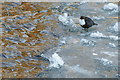
Dipper (Cinclus cinclus) on the Ericht at Blairgowrie
Dippers are specialists found along fast-flowing rivers, so icy weather rarely affects this species as much as other birds which specialise in freshwater habitats.
Image: © Mike Pennington
Taken: 24 Dec 2010
0.06 miles
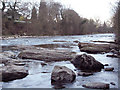
8
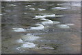
Frozen River Ericht at Blairgowrie
Ice forming around the stones in the river, although the reive is flowing around them.
Image: © Mike Pennington
Taken: 24 Dec 2010
0.08 miles
9
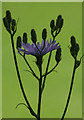
Common Blue Sow-thistle (Cicerbita macrophylla), Blairgowrie
Image: © Mike Pennington
Taken: 8 Jul 2007
0.08 miles
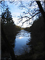
10
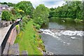
River Ericht, Blairgowrie
A view upstream from the bridge on Boat Brae carrying the A93.
Image: © Jim Barton
Taken: 23 Jun 2013
0.09 miles