IMAGES TAKEN NEAR TO
Davie Park Place, BLAIRGOWRIE, PH10 7BL
Introduction
This page details the photographs taken nearby to Davie Park Place, PH10 7BL by members of the Geograph project.
The Geograph project started in 2005 with the aim of publishing, organising and preserving representative images for every square kilometre of Great Britain, Ireland and the Isle of Man.

There are currently over 7.5m images from over14,400 individuals and you can help contribute to the project by visiting https://www.geograph.org.uk
Image Map
Images are licensed for reuse under creativecommons.org/licenses/by-sa/2.0
Notes
- Clicking on the map will re-center to the selected point.
- The higher the marker number, the further away the image location is from the centre of the postcode.
Image Listing (167 Images Found)
Images are licensed for reuse under creativecommons.org/licenses/by-sa/2.0
Image
Details
Distance
1
Ashgrove Road in Rattray
Looking north-westward.
Image: © Peter Wood
Taken: 28 Jun 2019
0.04 miles
2
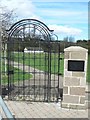
Ornamental gate
Memorial gate at Davie Park, Rattray.
Image: © James Allan
Taken: 26 Apr 2010
0.07 miles
3
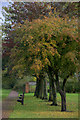
Trees and benches, Davie Park, Rattray
Image: © Mike Pennington
Taken: 20 Oct 2013
0.08 miles
5
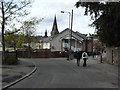
Spires in Rattray and Blairgowrie
The nearer spire is in Rattray, the farther in Blairgowrie. The two towns are virtually one, separated by the river Ericht.
Image: © James Allan
Taken: 26 Apr 2010
0.09 miles
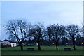
7
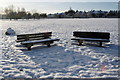
Davie Park, Rattray in snow
Snow has been lying for a week now, and plenty of people have walked through the park.
Image: © Mike Pennington
Taken: 28 Dec 2009
0.11 miles