IMAGES TAKEN NEAR TO
Balmoral Road, BLAIRGOWRIE, PH10 7AH
Introduction
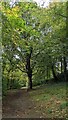
This page details the photographs taken nearby to Balmoral Road, PH10 7AH by members of the Geograph project.
The Geograph project started in 2005 with the aim of publishing, organising and preserving representative images for every square kilometre of Great Britain, Ireland and the Isle of Man.

There are currently over 7.5m images from over14,400 individuals and you can help contribute to the project by visiting https://www.geograph.org.uk
Image Map
Images are licensed for reuse under creativecommons.org/licenses/by-sa/2.0
Notes
- Clicking on the map will re-center to the selected point.
- The higher the marker number, the further away the image location is from the centre of the postcode.
Image Listing (68 Images Found)
Images are licensed for reuse under creativecommons.org/licenses/by-sa/2.0
Image
Details
Distance
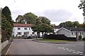
1
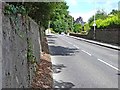
Balmoral Road, Rattray
The main A93 road north out of town.
Image: © Oliver Dixon
Taken: 11 Aug 2013
0.04 miles
2
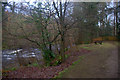
Bench beside the Ericht at the end of Riverside Road, Rattray
Image: © Mike Pennington
Taken: 1 Jan 2014
0.09 miles
3
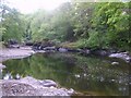
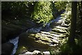
River Ericht
Passes through a rocky gorge on the outskirts of Blairgowrie
Image: © Michael Graham
Taken: 22 May 2010
0.10 miles
4
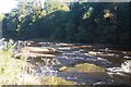
River Ericht
The river bed is made of conglomerate slabs here - just south of the Highland Boundary Fault.
Image: © Richard Webb
Taken: 2 Oct 2016
0.11 miles
5
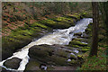
Cargill's Leap
The Ericht is forced through narrow channels in conglomerate rock here. The site is named after a Covenanter from Rattray who escaped capture by jumping the river here.
Image: © Richard Webb
Taken: 2 Oct 2016
0.12 miles
6
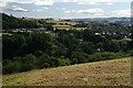
View over the Ericht valley from above Lornty
The caravan park at Westfields of Rattray is on the left and the trees mark the line of the Ericht.
Image: © Mike Pennington
Taken: 22 Jul 2008
0.12 miles
7
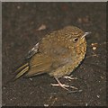
Robin (Erithacus rubecula), Blairgowrie
Juvenile Robins are brown and spotty, as adults are very territorial and so a red breast would provoke an aggressive reaction.
Image: © Mike Pennington
Taken: 2 Aug 2006
0.12 miles
8
Cargill's Leap
A similar view to Image, but taken in late winter.
Image: © Ian Taylor
Taken: 11 Mar 2017
0.12 miles
10
Victoria Street, Rattray
A dead end for motors, but there is a path out at the end of the rear right turn.
Image: © Richard Webb
Taken: 29 Sep 2018
0.12 miles