IMAGES TAKEN NEAR TO
Rosemount Park, BLAIRGOWRIE, PH10 6TZ
Introduction
This page details the photographs taken nearby to Rosemount Park, PH10 6TZ by members of the Geograph project.
The Geograph project started in 2005 with the aim of publishing, organising and preserving representative images for every square kilometre of Great Britain, Ireland and the Isle of Man.

There are currently over 7.5m images from over14,400 individuals and you can help contribute to the project by visiting https://www.geograph.org.uk
Image Map
Images are licensed for reuse under creativecommons.org/licenses/by-sa/2.0
Notes
- Clicking on the map will re-center to the selected point.
- The higher the marker number, the further away the image location is from the centre of the postcode.
Image Listing (14 Images Found)
Images are licensed for reuse under creativecommons.org/licenses/by-sa/2.0
Image
Details
Distance
1
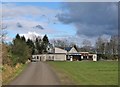
Rugby Club pavilion
This sports pavilion stands in the John Johnston Coupar Recreation Park, which is off the Coupar Angus Road, Blairgowrie. The sign above the entrance to the pavilion reads: 'Blairgowrie Rugby Club'.
Image: © Richard Dorrell
Taken: 24 Feb 2013
0.09 miles
2
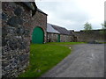
Old farm
Farm steading surviving on the fringe of Blairgowrie's suburban housing and its industrial sites.
Image: © James Allan
Taken: 13 May 2013
0.15 miles
4
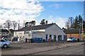
Business premises, Coupar Angus Road
The warehouse size building is selling hardware and garden items, and to the side has a coin-operated jet wash for car washing.
Image: © Richard Dorrell
Taken: 24 Feb 2013
0.15 miles
5
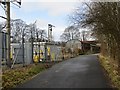
Welton Road, Blairgowrie
Passing an electricity substation.
Image: © Richard Webb
Taken: 22 Feb 2014
0.18 miles
6
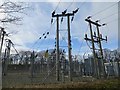
Substation, Blairgowrie
On Welton Road, near the River Ericht.
Image: © Richard Webb
Taken: 22 Feb 2014
0.19 miles
7
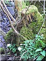
Mossy tree stump
Close to the bank of the river Ericht.
Image: © James Allan
Taken: 26 Apr 2010
0.20 miles
8
Blairgowrie's suburbia
Housing in Paterson Drive seen from the end of Cedar Avenue, on a built-up part of the Ardblair Trail.
Image: © James Allan
Taken: 13 May 2013
0.21 miles
9
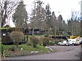
Altamount chalet accommodation
The wooded grounds of the Altamount Hotel, close to Blairgowrie town centre, are home to a park of timber chalets which are available year-round for self catering holiday accommodation.
Image: © Richard Dorrell
Taken: 24 Feb 2013
0.22 miles
10
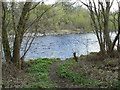
Angler's path
Beside the river Ericht near Blairgowrie.
Image: © James Allan
Taken: 26 Apr 2010
0.22 miles