IMAGES TAKEN NEAR TO
BLAIRGOWRIE, PH10 6TF
Introduction
This page details the photographs taken nearby to PH10 6TF by members of the Geograph project.
The Geograph project started in 2005 with the aim of publishing, organising and preserving representative images for every square kilometre of Great Britain, Ireland and the Isle of Man.

There are currently over 7.5m images from over14,400 individuals and you can help contribute to the project by visiting https://www.geograph.org.uk
Image Map
Images are licensed for reuse under creativecommons.org/licenses/by-sa/2.0
Notes
- Clicking on the map will re-center to the selected point.
- The higher the marker number, the further away the image location is from the centre of the postcode.
Image Listing (8 Images Found)
Images are licensed for reuse under creativecommons.org/licenses/by-sa/2.0
Image
Details
Distance
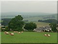
2
Wheatfield, Mause, north of Blairgowrie
Showing the top of the small but deep gully which was bridged on the old A94 and which lead to the recent realignment of the road.
Image: © Mike Pennington
Taken: 7 Aug 2009
0.18 miles
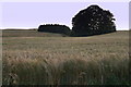
3
Farmland, Mause
I'm a lot closer to the grid line than I am normally comfortable with and have had to check the location against Where's the path. I was in, just! This is taken through the hedge of a farm road, part of Blairgowrie and Rattray's core path network. The A93 is near by but does not enter the square.
The field appears to have been left fallow.
Image: © Richard Webb
Taken: 2 Oct 2016
0.20 miles
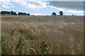
4
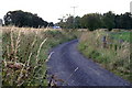
Farm road, Mause
Now signposted and waymarked this older road runs beside the new alignment of the A93. Very pleasant arable countryside near the Highland Boundary Fault north of Rattray.
Image: © Richard Webb
Taken: 2 Oct 2016
0.21 miles
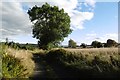
5
Track to Middle Mause, north of Blairgowrie
Image: © Mike Pennington
Taken: 7 Aug 2009
0.22 miles
6
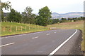
New A93 realignment at Craighall
Looking south towards Blairgowrie, this new road was built to avoid a narrow section above Craighall Gorge which included a single-track traffic-light-controlled bridge.
Image: © Mike Pennington
Taken: 7 Aug 2009
0.23 miles
7
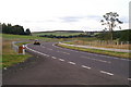
New A93 realignment at Craighall
Looking north towards Bridge of Cally, this new road was built to avoid a narrow section above Craighall Gorge which included a single-track traffic-light-controlled bridge.
Image: © Mike Pennington
Taken: 7 Aug 2009
0.24 miles
8
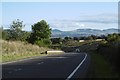
New alignment of the A93
A new road was built after 40 years of temporary lights on a Bailey bridge across a landslide gully on the old road down by the Ericht. At this end, if travelling south, there is a very fast descent to the bridge over the Ericht just north of Rattray.
Image: © Richard Webb
Taken: 2 Oct 2016
0.25 miles