IMAGES TAKEN NEAR TO
BLAIRGOWRIE, PH10 6SN
Introduction
This page details the photographs taken nearby to PH10 6SN by members of the Geograph project.
The Geograph project started in 2005 with the aim of publishing, organising and preserving representative images for every square kilometre of Great Britain, Ireland and the Isle of Man.

There are currently over 7.5m images from over14,400 individuals and you can help contribute to the project by visiting https://www.geograph.org.uk
Image Map
Images are licensed for reuse under creativecommons.org/licenses/by-sa/2.0
Notes
- Clicking on the map will re-center to the selected point.
- The higher the marker number, the further away the image location is from the centre of the postcode.
Image Listing (5 Images Found)
Images are licensed for reuse under creativecommons.org/licenses/by-sa/2.0
Image
Details
Distance
2
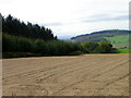
Prepared field near Forneth
The field has been sown with this years crop. The shelter belt is not named.
Image: © Maigheach-gheal
Taken: 16 Apr 2011
0.06 miles
3
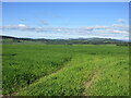
Field near Loaning
Looking south-west across a field from the roadside at Loaning.
Image: © Scott Cormie
Taken: 6 Jun 2021
0.13 miles
4
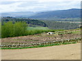
Pheasant pen, Forneth
In the field of game cover there is a pheasant release pen or a pheasant laying pen.
Image: © Maigheach-gheal
Taken: 16 Apr 2011
0.24 miles
5
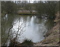
Mallard on duck pond
His mate was out of shot!
Image: © Russel Wills
Taken: 27 Mar 2010
0.24 miles