IMAGES TAKEN NEAR TO
BLAIRGOWRIE, PH10 6SF
Introduction
This page details the photographs taken nearby to PH10 6SF by members of the Geograph project.
The Geograph project started in 2005 with the aim of publishing, organising and preserving representative images for every square kilometre of Great Britain, Ireland and the Isle of Man.

There are currently over 7.5m images from over14,400 individuals and you can help contribute to the project by visiting https://www.geograph.org.uk
Image Map
Images are licensed for reuse under creativecommons.org/licenses/by-sa/2.0
Notes
- Clicking on the map will re-center to the selected point.
- The higher the marker number, the further away the image location is from the centre of the postcode.
Image Listing (14 Images Found)
Images are licensed for reuse under creativecommons.org/licenses/by-sa/2.0
Image
Details
Distance
1
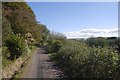
Road from Millhole
One of the outer branches of the tree of roads serving dwellings above Blairgowrie.
Image: © Richard Webb
Taken: 2 Oct 2016
0.06 miles
2
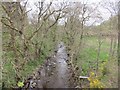
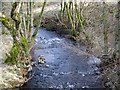
Lornty Burn
The Lornty Burn heading upstream near West Gormack.
Image: © Scott Cormie
Taken: 5 May 2019
0.08 miles
3
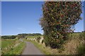
Road to Middleton
Passing a heavily laden rowan.
Image: © Richard Webb
Taken: 2 Oct 2016
0.08 miles
4
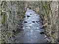
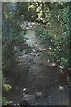
Lornty Burn, West Gormack
The burn looking upstream from the Bridge of Drummed.
Image: © Maigheach-gheal
Taken: 31 Mar 2010
0.08 miles
5
Lornty Burn, West Gormack
Looking downstream.
Image: © Maigheach-gheal
Taken: 31 Mar 2010
0.09 miles
6
Lornty Burn at West Gormack, near Kinloch
Looking downstream.
Image: © Mike Pennington
Taken: 7 Aug 2009
0.10 miles
7
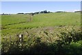
Fields by Middleton (Perthshire)
Looking towards Westerton.
Image: © Richard Webb
Taken: 2 Oct 2016
0.11 miles
8
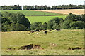
Beef cattle, West Gormack, near Kinloch
The trees mark the course of the Lornty Burn.
Image: © Mike Pennington
Taken: 7 Aug 2009
0.11 miles
9
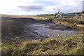
Pond, West Gormack
Recently dug out wet depression.
Image: © Richard Webb
Taken: 28 Oct 2017
0.15 miles
10
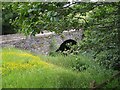
Bridge over Lornty Burn
The minor road past West Gormack to Middleton farm does a dog leg to cross this old stone bridge over the burn in its steep glen.
Image: © Lis Burke
Taken: 29 Jul 2006
0.16 miles