IMAGES TAKEN NEAR TO
BLAIRGOWRIE, PH10 6RZ
Introduction
This page details the photographs taken nearby to PH10 6RZ by members of the Geograph project.
The Geograph project started in 2005 with the aim of publishing, organising and preserving representative images for every square kilometre of Great Britain, Ireland and the Isle of Man.

There are currently over 7.5m images from over14,400 individuals and you can help contribute to the project by visiting https://www.geograph.org.uk
Image Map
Images are licensed for reuse under creativecommons.org/licenses/by-sa/2.0
Notes
- Clicking on the map will re-center to the selected point.
- The higher the marker number, the further away the image location is from the centre of the postcode.
Image Listing (11 Images Found)
Images are licensed for reuse under creativecommons.org/licenses/by-sa/2.0
Image
Details
Distance
1
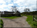
Myreside Farm
Somewhat dilapidated farm buildings.
Image: © James Allan
Taken: 13 May 2013
0.04 miles
2

Horses at Myreside, Blairgowrie
The footpath of the Ardblair trail cuts across the fields here.
Image: © Mike Pennington
Taken: 15 Oct 2008
0.08 miles
3
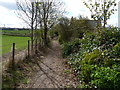
Ardblair trail footpath
Forming part of the circular walk known as the Ardblair Trail, this path is just north of the A923 Dunkeld Road.
Image: © James Allan
Taken: 13 May 2013
0.13 miles
4
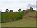
Tall and straight, Blairgowrie
Several varieties of poplar have been planted along this hedge line and the Galabank Path can just be seen where the trees have been felled.
Image: © Maigheach-gheal
Taken: 16 Apr 2011
0.16 miles
5
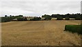
Barley stubble
Galabank off the Dunkeld Road on the edge of Blairgowrie.
Image: © Richard Webb
Taken: 6 Sep 2013
0.20 miles
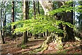
6
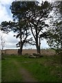
Two fine pines
Beside a footpath corner on the Ardblair Trail.
Image: © James Allan
Taken: 13 May 2013
0.22 miles
7
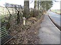
Milepost, Ardblair
Milepost beside the A923.
Milestones/mileposts are the original roadside heritage features with many dating back hundreds of years and these historic items are under threat from highway developments.
Image: © Maigheach-gheal
Taken: 31 Mar 2010
0.22 miles
8
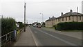
Dunkeld Road
On the outside of Blairgowrie, looking in.
Image: © Richard Webb
Taken: 6 Sep 2013
0.24 miles
9
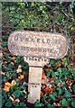
Old Milepost by the A923, Dunkeld Road, Blairgowrie parish
Milepost by the A923, in parish of Blairgowrie (Perth & Kinross District), Ardblair Castle, on verge.
Inscription reads:-
DUNKELD 11
BLAIRGOWRIE 1
FORNETH
Surveyed
Milestone Society National ID: PK_BGDK01
Image: © Milestone Society
Taken: Unknown
0.24 miles