IMAGES TAKEN NEAR TO
BLAIRGOWRIE, PH10 6RN
Introduction
This page details the photographs taken nearby to PH10 6RN by members of the Geograph project.
The Geograph project started in 2005 with the aim of publishing, organising and preserving representative images for every square kilometre of Great Britain, Ireland and the Isle of Man.

There are currently over 7.5m images from over14,400 individuals and you can help contribute to the project by visiting https://www.geograph.org.uk
Image Map
Images are licensed for reuse under creativecommons.org/licenses/by-sa/2.0
Notes
- Clicking on the map will re-center to the selected point.
- The higher the marker number, the further away the image location is from the centre of the postcode.
Image Listing (5 Images Found)
Images are licensed for reuse under creativecommons.org/licenses/by-sa/2.0
Image
Details
Distance
1
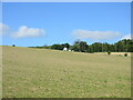
Craigie Wallace
A distant view of Craigie Wallace from the field to the north-east.
Image: © Scott Cormie
Taken: 6 Jun 2021
0.01 miles
3
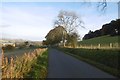
Descent to Clunie
A long descent on the road from Loch of the Lowes.
Image: © Richard Webb
Taken: 30 Oct 2016
0.20 miles
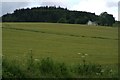
5
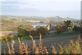
View of Clunie
A view from the Loch of the Lowes road towards the church and loch at Clunie.
Image: © Richard Webb
Taken: 30 Oct 2016
0.25 miles