IMAGES TAKEN NEAR TO
BLAIRGOWRIE, PH10 6RJ
Introduction
This page details the photographs taken nearby to PH10 6RJ by members of the Geograph project.
The Geograph project started in 2005 with the aim of publishing, organising and preserving representative images for every square kilometre of Great Britain, Ireland and the Isle of Man.

There are currently over 7.5m images from over14,400 individuals and you can help contribute to the project by visiting https://www.geograph.org.uk
Image Map
Images are licensed for reuse under creativecommons.org/licenses/by-sa/2.0
Notes
- Clicking on the map will re-center to the selected point.
- The higher the marker number, the further away the image location is from the centre of the postcode.
Image Listing (5 Images Found)
Images are licensed for reuse under creativecommons.org/licenses/by-sa/2.0
Image
Details
Distance
1
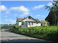
Clunie Hall
Clunie Village Hall, viewed from the adjacent road to the south.
Image: © Scott Cormie
Taken: 6 Jun 2021
0.03 miles
3
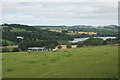
Concraigie and Loch of Clunie
Concraigie is the group of farm buildings. The white-painted property above and to the left of these is Forneth House.
Image: © Richard Sutcliffe
Taken: 12 Aug 2015
0.17 miles
5
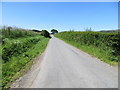
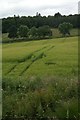
Hedge-lined minor road near to Milton of Clunie
Looking north-westward.
Image: © Peter Wood
Taken: 28 Jun 2019
0.25 miles