IMAGES TAKEN NEAR TO
Craigie, BLAIRGOWRIE, PH10 6RG
Introduction
This page details the photographs taken nearby to Craigie, PH10 6RG by members of the Geograph project.
The Geograph project started in 2005 with the aim of publishing, organising and preserving representative images for every square kilometre of Great Britain, Ireland and the Isle of Man.

There are currently over 7.5m images from over14,400 individuals and you can help contribute to the project by visiting https://www.geograph.org.uk
Image Map
Images are licensed for reuse under creativecommons.org/licenses/by-sa/2.0
Notes
- Clicking on the map will re-center to the selected point.
- The higher the marker number, the further away the image location is from the centre of the postcode.
Image Listing (18 Images Found)
Images are licensed for reuse under creativecommons.org/licenses/by-sa/2.0
Image
Details
Distance
2
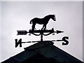
Weather vane, Craigie
As long as humans have farmed the land, sailed the seas and contemplated their place in nature, the wind has played a key role in their speculations. It was interpreting the wind's changing direction that helped our ancestors predict the coming weather and survive.
Image: © Maigheach-gheal
Taken: 31 Mar 2010
0.09 miles
4
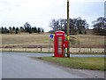
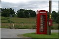
Telephone box, Craigie
A K6 type telephone box stands at a junction of minor roads.
In 1935, the Post Office commissioned a new kiosk from Sir Giles Gilbert Scott to celebrate the Jubilee of King George V. The K6 Jubilee Kiosk, as it is known, was similar to the K2 box, being made of cast iron and painted red but was 25% lighter in weight. By the end of the 1930s there were 20,000 K6 telephone boxes in use all over the UK.
Image: © Maigheach-gheal
Taken: 31 Mar 2010
0.09 miles
5
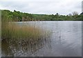
Loch of Clunie
Clunie is Gealic for meadow.
Image: © Maigheach-gheal
Taken: 23 May 2008
0.16 miles
6

Water Forget-me-not (Myosotis scorpioides), Clunie
A common plant in marshy areas.
Image: © Mike Pennington
Taken: 9 Jul 2007
0.17 miles
7

Goosegrass (Galium aparine), Loch Clunie
Also known as Cleavers or Stickywilly, this is a common weed over most of Britain.
Image: © Mike Pennington
Taken: 9 Jul 2007
0.17 miles
8
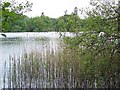
Loch of Clunie
Freshwater loch situated close to the main A923 between the towns of Dunkeld and Blairgowrie.
Image: © Maigheach-gheal
Taken: 23 May 2008
0.17 miles
9
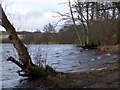
Loch of Clunie
Freshwater loch situated close to the main A923 between the towns of Dunkeld and Blairgowrie.
Image: © Maigheach-gheal
Taken: 31 Mar 2010
0.17 miles
10
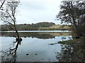
Loch of Clunie
On the southern edge of the loch, looking north.
Image: © Rob Burke
Taken: 13 Nov 2005
0.18 miles