IMAGES TAKEN NEAR TO
BLAIRGOWRIE, PH10 6RA
Introduction
This page details the photographs taken nearby to PH10 6RA by members of the Geograph project.
The Geograph project started in 2005 with the aim of publishing, organising and preserving representative images for every square kilometre of Great Britain, Ireland and the Isle of Man.

There are currently over 7.5m images from over14,400 individuals and you can help contribute to the project by visiting https://www.geograph.org.uk
Image Map
Images are licensed for reuse under creativecommons.org/licenses/by-sa/2.0
Notes
- Clicking on the map will re-center to the selected point.
- The higher the marker number, the further away the image location is from the centre of the postcode.
Image Listing (4 Images Found)
Images are licensed for reuse under creativecommons.org/licenses/by-sa/2.0
Image
Details
Distance
1
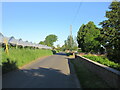
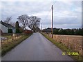
C432 (Perth and Kinross) Road
The C432 road heading west near Wester Essendy.
Image: © Scott Cormie
Taken: 6 Jun 2021
0.09 miles
2
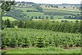
Christmas tree plantation at Wester Essendy
Image: © Mike Pennington
Taken: 9 Jul 2007
0.09 miles
4
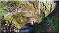
OS Benchmark Rivet
Os Benchmark rivet set into a stone wall.
Ref: https://www.bench-marks.org.uk/bm165605
Image: © Karl Peet
Taken: 19 Mar 2022
0.21 miles