1
Fire engines outside Blairgowrie Recreation Centre
The fire alarm was set off just as a junior swimming lesson was starting - a bit chilly for the bairns evacuated in survival blankets.
Image: © Mike Pennington
Taken: 10 Apr 2014
0.13 miles
2
The signs say it all
An abandoned pavilion and snow-covered tennis courts are the now-disused Blairgowrie Tennis Club site. The land fronts onto Coupar Angus Road, close to the town centre, and the sign on the left clearly shows the site is currently for sale for residential development.
Image: © Richard Dorrell
Taken: 24 Feb 2013
0.15 miles
3
Blairgowrie High School
Located in Beeches Road, Blairgowrie. This High School has a roll of about 860 pupils.
Image: © Richard Dorrell
Taken: 24 Feb 2013
0.17 miles
4
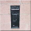
Black Victorian Wallbox
Black painted VR wallbox on the corner of the A93 Perth Road and A923 Dunkeld Road in Blairgowrie.
Image: © Scott Cormie
Taken: 24 Dec 2021
0.18 miles
5
Vehicle repair workshop, Blairgowrie
Occupying a town-centre position in Jessie Street, this is the premises of Walter A Crole and Son, car and commercial body repair centre. The photograph was taken on a Sunday, when the workshop was closed.
Image: © Richard Dorrell
Taken: 24 Feb 2013
0.18 miles
6
Perth Road, Blairgowrie
The A93 heading northwards towards Blairgowrie town centre.
Image: © Scott Cormie
Taken: 5 May 2019
0.18 miles
7
Crossroads on Bankhead, Blairgowrie
From Emma Street looking towards Back Brae across Bankhead.
Image: © Mike Pennington
Taken: 16 Oct 2011
0.19 miles
8
Blairgowrie Community Hospital
Viewed from the junction of Perth Road and Ann Street. The premises opened as Blairgowrie and Rattray Districts Cottage Hospital on 30th May 1901.
Image: © Richard Dorrell
Taken: 24 Feb 2013
0.19 miles
9
Heading into Blairgowrie on the A93
Blairgowrie Cottage Hospital just out of picture to the left.
Image: © Karl Peet
Taken: 10 May 2006
0.19 miles
10
Perth Road, Blairgowrie
Looking north towards the town centre. On the left is West Altamount Lane, on the right is Beeches Road.
Image: © Richard Dorrell
Taken: 24 Feb 2013
0.19 miles


