IMAGES TAKEN NEAR TO
Drummond Road, BLAIRGOWRIE, PH10 6PD
Introduction
This page details the photographs taken nearby to Drummond Road, PH10 6PD by members of the Geograph project.
The Geograph project started in 2005 with the aim of publishing, organising and preserving representative images for every square kilometre of Great Britain, Ireland and the Isle of Man.

There are currently over 7.5m images from over14,400 individuals and you can help contribute to the project by visiting https://www.geograph.org.uk
Image Map
Images are licensed for reuse under creativecommons.org/licenses/by-sa/2.0
Notes
- Clicking on the map will re-center to the selected point.
- The higher the marker number, the further away the image location is from the centre of the postcode.
Image Listing (11 Images Found)
Images are licensed for reuse under creativecommons.org/licenses/by-sa/2.0
Image
Details
Distance
1
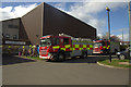
Fire engines outside Blairgowrie Recreation Centre
The fire alarm was set off just as a junior swimming lesson was starting - a bit chilly for the bairns evacuated in survival blankets.
Image: © Mike Pennington
Taken: 10 Apr 2014
0.05 miles
2
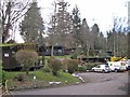
Altamount chalet accommodation
The wooded grounds of the Altamount Hotel, close to Blairgowrie town centre, are home to a park of timber chalets which are available year-round for self catering holiday accommodation.
Image: © Richard Dorrell
Taken: 24 Feb 2013
0.17 miles
3
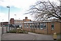
Blairgowrie High School
Located in Beeches Road, Blairgowrie. This High School has a roll of about 860 pupils.
Image: © Richard Dorrell
Taken: 24 Feb 2013
0.18 miles
4
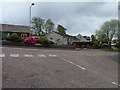
Blairgowrie's suburbia
Housing in Paterson Drive seen from the end of Cedar Avenue, on a built-up part of the Ardblair Trail.
Image: © James Allan
Taken: 13 May 2013
0.19 miles
5
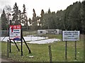
The signs say it all
An abandoned pavilion and snow-covered tennis courts are the now-disused Blairgowrie Tennis Club site. The land fronts onto Coupar Angus Road, close to the town centre, and the sign on the left clearly shows the site is currently for sale for residential development.
Image: © Richard Dorrell
Taken: 24 Feb 2013
0.19 miles
6
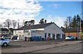
Business premises, Coupar Angus Road
The warehouse size building is selling hardware and garden items, and to the side has a coin-operated jet wash for car washing.
Image: © Richard Dorrell
Taken: 24 Feb 2013
0.21 miles
7
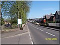
Heading into Blairgowrie on the A93
Blairgowrie Cottage Hospital just out of picture to the left.
Image: © Karl Peet
Taken: 10 May 2006
0.23 miles
8
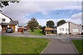
Paths, Blairgowrie
There is a network of paths amongst the new houses to the south of the town centre. Notice how the ground is worn where folk have dodged the unnecessary and annoying obstacles on the path. I bet they are great fun in a wheelchair or with a pushchair.
Image: © Richard Webb
Taken: 29 Sep 2018
0.24 miles
9
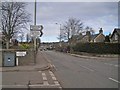
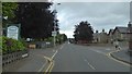
Perth Road, Blairgowrie
Looking north towards the town centre. On the left is West Altamount Lane, on the right is Beeches Road.
Image: © Richard Dorrell
Taken: 24 Feb 2013
0.24 miles