IMAGES TAKEN NEAR TO
Moyness Park Drive, BLAIRGOWRIE, PH10 6LX
Introduction
This page details the photographs taken nearby to Moyness Park Drive, PH10 6LX by members of the Geograph project.
The Geograph project started in 2005 with the aim of publishing, organising and preserving representative images for every square kilometre of Great Britain, Ireland and the Isle of Man.

There are currently over 7.5m images from over14,400 individuals and you can help contribute to the project by visiting https://www.geograph.org.uk
Image Map
Images are licensed for reuse under creativecommons.org/licenses/by-sa/2.0
Notes
- Clicking on the map will re-center to the selected point.
- The higher the marker number, the further away the image location is from the centre of the postcode.
Image Listing (4 Images Found)
Images are licensed for reuse under creativecommons.org/licenses/by-sa/2.0
Image
Details
Distance
1
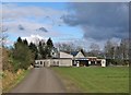
Rugby Club pavilion
This sports pavilion stands in the John Johnston Coupar Recreation Park, which is off the Coupar Angus Road, Blairgowrie. The sign above the entrance to the pavilion reads: 'Blairgowrie Rugby Club'.
Image: © Richard Dorrell
Taken: 24 Feb 2013
0.13 miles
2
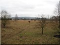
Future building land? Rosemount
A large field that has had no agricultural activity for some time. Probably lined up for house building. It is an illustration of what happens when grazing ceases, the open field is turning into woodland.
Image: © Richard Webb
Taken: 24 Feb 2007
0.20 miles
3
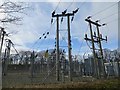
Substation, Blairgowrie
On Welton Road, near the River Ericht.
Image: © Richard Webb
Taken: 22 Feb 2014
0.23 miles
4
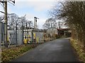
Welton Road, Blairgowrie
Passing an electricity substation.
Image: © Richard Webb
Taken: 22 Feb 2014
0.24 miles