IMAGES TAKEN NEAR TO
Coupar Angus Road, BLAIRGOWRIE, PH10 6LU
Introduction
This page details the photographs taken nearby to Coupar Angus Road, PH10 6LU by members of the Geograph project.
The Geograph project started in 2005 with the aim of publishing, organising and preserving representative images for every square kilometre of Great Britain, Ireland and the Isle of Man.

There are currently over 7.5m images from over14,400 individuals and you can help contribute to the project by visiting https://www.geograph.org.uk
Image Map
Images are licensed for reuse under creativecommons.org/licenses/by-sa/2.0
Notes
- Clicking on the map will re-center to the selected point.
- The higher the marker number, the further away the image location is from the centre of the postcode.
Image Listing (6 Images Found)
Images are licensed for reuse under creativecommons.org/licenses/by-sa/2.0
Image
Details
Distance
2
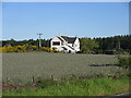
Stormont Crossing Cottage
White house viewed from the A923 near Stormont Loch.
Image: © Scott Cormie
Taken: 5 Jun 2022
0.16 miles
3
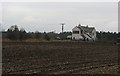
Arable land, Rosemount
Ploughed field between the railway (dismantled) and road between Coupar Angus and Blairgowrie.
Image: © Richard Webb
Taken: 24 Feb 2007
0.17 miles
4
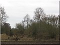
Old railway to Blairgowrie
The route of an old branch line running up from Coupar Angus, closed to passengers in 1955 and finally dismantled in 1965. The woodland beyond surrounds the Stormont Loch.
Image: © Richard Webb
Taken: 24 Feb 2007
0.21 miles
5
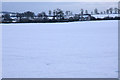
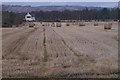
Fields at Rosemount, Blairgowrie
Looking across snowy fields to the large house at Ardmuir on the Coupar Angus Road.
Image: © Mike Pennington
Taken: 27 Dec 2009
0.23 miles
6
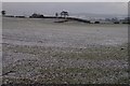
Farmland at Rosemount
With a light dusting of snow.
Image: © Mike Pennington
Taken: 4 Jan 2008
0.24 miles