IMAGES TAKEN NEAR TO
Reform Street, BLAIRGOWRIE, PH10 6BF
Introduction
This page details the photographs taken nearby to Reform Street, PH10 6BF by members of the Geograph project.
The Geograph project started in 2005 with the aim of publishing, organising and preserving representative images for every square kilometre of Great Britain, Ireland and the Isle of Man.

There are currently over 7.5m images from over14,400 individuals and you can help contribute to the project by visiting https://www.geograph.org.uk
Image Map
Images are licensed for reuse under creativecommons.org/licenses/by-sa/2.0
Notes
- Clicking on the map will re-center to the selected point.
- The higher the marker number, the further away the image location is from the centre of the postcode.
Image Listing (219 Images Found)
Images are licensed for reuse under creativecommons.org/licenses/by-sa/2.0
Image
Details
Distance
1
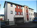
Picture House Court, Blairgowrie
Recent housing.
Image: © Jonathan Thacker
Taken: 4 Dec 2013
0.02 miles
2
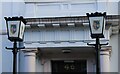
Council lamps
The two lamps, each bearing the coat of arms of Blairgowrie and Rattray stand outside the entrance to the council offices on Leslie Street in Blairgowrie Image
Image: © Richard Sutcliffe
Taken: 31 Oct 2023
0.02 miles
3
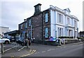
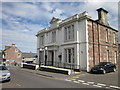
Council offices and Library, Blairgowrie
The building (originally Bleaton House) dates from the early to mid 19th century. It was acquired by the North Bank of Scotland in 1881 and was later converted to local authority offices. The library is housed in a modern extension at the back. It is Category B listed https://portal.historicenvironment.scot/designation/LB22316.
Image: © Richard Sutcliffe
Taken: 31 Oct 2023
0.03 miles
4
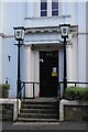
Entrance to council offices
The building Image (originally Bleaton House) dates from the early to mid 19th century. It was acquired by the North Bank of Scotland in 1881 and was later converted to local authority offices. It is Category B listed https://portal.historicenvironment.scot/designation/LB22316.
Image: © Richard Sutcliffe
Taken: 31 Oct 2023
0.03 miles
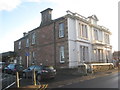
5
Council Office and Library, Blairgowrie
The Blairgowrie area office for Perth and Kinross Council is situated in Leslie Street.
Image: © Ian Murfitt
Taken: 19 Aug 2011
0.03 miles
6
Council Offices, Blairgowrie
A mid nineteenth century house converted for public use.
Image: © Jonathan Thacker
Taken: 4 Dec 2013
0.03 miles
8
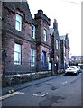
Blairgowrie Police Station
On Ericht Lane. Built in 1913 and Category C listed https://portal.historicenvironment.scot/designation/LB49424.
Image: © Richard Sutcliffe
Taken: 31 Oct 2023
0.04 miles
9
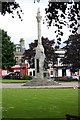
War Memorial Blairgowrie
The War memorial in Blairgowrie.
Very close to Eastern edge of the square.
Image: © Paul Store
Taken: 13 Jun 2005
0.04 miles
10
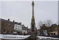
War Memorial in Wellmeadow, Blairgowrie
Image: © Alan Morrison
Taken: 14 Feb 2009
0.04 miles