
IMAGES TAKEN NEAR TO
Shepherds Walk, STAMFORD, PE9 4JG
Introduction
This page details the photographs taken nearby to Shepherds Walk, PE9 4JG by members of the Geograph project.
The Geograph project started in 2005 with the aim of publishing, organising and preserving representative images for every square kilometre of Great Britain, Ireland and the Isle of Man.

There are currently over 7.5m images from over14,400 individuals and you can help contribute to the project by visiting https://www.geograph.org.uk
Image Map
Images are licensed for reuse under creativecommons.org/licenses/by-sa/2.0
Notes
- Clicking on the map will re-center to the selected point.
- The higher the marker number, the further away the image location is from the centre of the postcode.
Image Listing (51 Images Found)
Images are licensed for reuse under creativecommons.org/licenses/by-sa/2.0
Image
Details
Distance

2
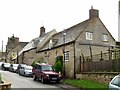
Blue Bell Inn, Belmesthorpe
Parts of the building date back to the 17th century, with additions over the centuries. The roof is partly slate and partly traditional Collyweston stone slate. Listed Grade II.
Image: © Alan Murray-Rust
Taken: 7 Jan 2016
0.00 miles

4

Detail of the Blue Bell Inn
Some interesting coursing of the stonework which suggests some partial collapse of the structure at some time. See also http://www.geograph.org.uk/photo/4787742.
Image: © Alan Murray-Rust
Taken: 7 Jan 2016
0.01 miles

6

Blue Bell Cottage and the Blue Bell Inn
All the on-street parking was due to the fact that the pub car park was being resurfaced.
Image: © Alan Murray-Rust
Taken: 7 Jan 2016
0.01 miles
7

Wisteria Cottage, Belmesthorpe
19th century 2-unit house in coursed limestone rubble with Collyweston stone slate roof.
Image: © Alan Murray-Rust
Taken: 7 Jan 2016
0.02 miles
8

Fingerpost and village sign, Belmesthorpe
Standard Rutland County Council concrete post, which has been put to good use to support the village sign.
Image: © Alan Murray-Rust
Taken: 7 Jan 2016
0.03 miles
9

Road junction and grass triangle
Grass covered road junction slitter in Belmesthorpe.
Image: © Michael Trolove
Taken: 25 Sep 2016
0.03 miles
10

Green at Belmesthorpe
Triangular mini-green with fingerpost and village sign http://www.geograph.org.uk/photo/4787712, flanked by 17th century cottages http://www.geograph.org.uk/photo/4787710.
Image: © Alan Murray-Rust
Taken: 7 Jan 2016
0.03 miles