
IMAGES TAKEN NEAR TO
Scotgate, STAMFORD, PE9 2YB
Introduction
This page details the photographs taken nearby to Scotgate, PE9 2YB by members of the Geograph project.
The Geograph project started in 2005 with the aim of publishing, organising and preserving representative images for every square kilometre of Great Britain, Ireland and the Isle of Man.

There are currently over 7.5m images from over14,400 individuals and you can help contribute to the project by visiting https://www.geograph.org.uk
Image Map
Images are licensed for reuse under creativecommons.org/licenses/by-sa/2.0
Notes
- Clicking on the map will re-center to the selected point.
- The higher the marker number, the further away the image location is from the centre of the postcode.
Image Listing (1852 Images Found)
Images are licensed for reuse under creativecommons.org/licenses/by-sa/2.0
Image
Details
Distance


3

5 Scotgate, Stamford
Formerly the Scotgate Inn, now converted to offices. Built in 1871, red brick with terracotta dressings, imitating stonework, from the local Blashfield's Works. Listed Grade II.
Image: © Alan Murray-Rust
Taken: 3 Mar 2020
0.01 miles
4

5 Scotgate, Stamford ? detail
Part of the parapet, inscribed “P & R PHIPPS. BREWERS”, with their crest over, all in terracotta. See http://www.geograph.org.uk/photo/6410241 for location and more information..
Image: © Alan Murray-Rust
Taken: 3 Mar 2020
0.01 miles
5

Stamford: along Scotgate
The spire of St Mary's, the tower of St John's and the brewery chimney point skywards. On the right is the former Scotgate public house, which carries the name of Phipps, the Northampton brewer.
Image: © John Sutton
Taken: 7 Feb 2017
0.02 miles
6
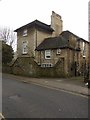
4 Scotgate, Stamford
Also known as Brewery House, early 19th century, Listed Grade II.
Image: © Alan Murray-Rust
Taken: 3 Mar 2020
0.02 miles
7

Scotgate, Stamford
Looking away from the town centre just by the corner of Barn Hill on the right.
Image: © Andrew Hill
Taken: 7 May 2010
0.02 miles
8

Stamford: Scotgate
The ornate brick building is the former Scotgate public house, inscribed with the name of P & R Phipps, the Northampton brewer. Urban Edge is an architectural practice based here on the edge of the historic town centre.
Image: © John Sutton
Taken: 7 Feb 2017
0.03 miles
9
![Stamford houses [4]](https://s3.geograph.org.uk/geophotos/07/13/27/7132759_c580dd4c_120x120.jpg)
Stamford houses [4]
Brewery House, number 4 Scotgate, was built in the early 19th century. Constructed of coursed rubble stone under a stone slate roof. Listed, grade II, with details at: https://historicengland.org.uk/listing/the-list/list-entry/1170253
Stamford is a market town on the southern border of Lincolnshire, located at the lowest point that the River Welland could be forded. It is some 11 miles northwest of Peterborough and about 27 miles east of Leicester, and is set on Roman Ermine Street and the Great North Road. The picturesque town is constructed almost entirely of limestone, much of the town centre was built in the 17th and 18th centuries in Jacobean or Georgian style. Tourism is an important element of Stamford’s economy.
Image: © Michael Dibb
Taken: 27 Sep 2021
0.03 miles
